
Airborne support in the search for survivors and landmines: in the wake of a natural disaster this past May in Serbia and Bosnia and Herzegovina, rescue teams have been using German-made drones. Flooding and landslides left many people homeless, blocked access to large areas and brought civil-war landmines to the surface. The EU’s ICARUS and TIRAMISU development projects are providing support for the search for survivors and landmines. In a number of sorties over flooded regions, the drones have proven to be highly useful. And now the UN, too, is again using airborne support.
AIRBORNE SUPPORT
When, this past May, large areas along the Save and Bosna rivers and its tributaries were flooded, resulting in numerous landslides, it soon became clear that this were the heaviest rainfall in decades. The potentially life-threatening hazards to which the populace was exposed continued long after the storms abated. The EU estimated the damage and economic loss at around €2 billion in Bosnia and Herzegovina, and an additional €1.5 billion in Serbia. In view of the scope of the disaster, the EU pledging and donor conference swiftly allocated €809.2 million and €995.2 million in aid to Bosnia and Herzegovina and Serbia respectively.
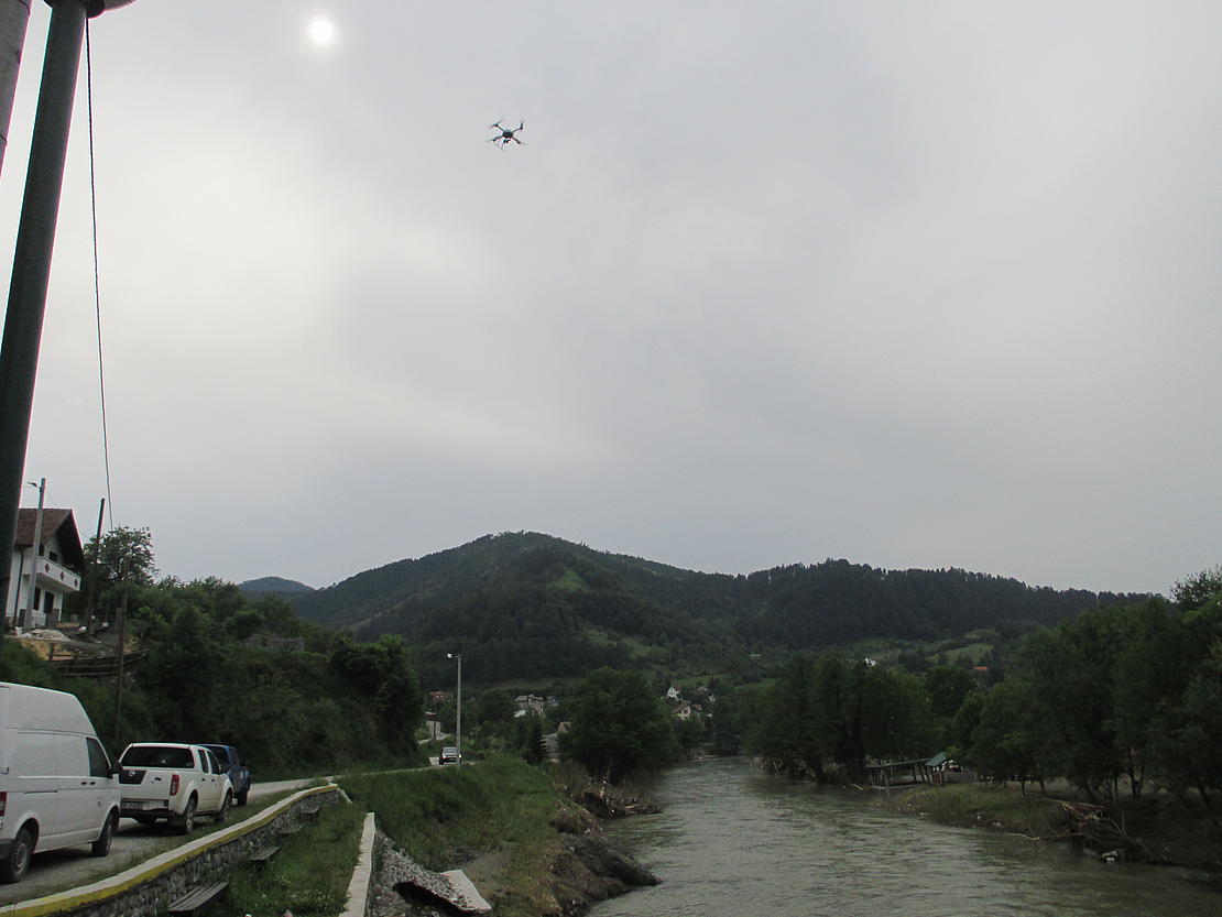
Disaster struck the region again in early August, in the form of further flooding resulting from heavy rainfall. Cleanup was in progress when the new flooding occurred, and is still ongoing. But local officials and others in positions of responsibility are overwhelmed. Many international aid organizations have been doing their part to help, including Belgium’s Royal Military Academy (RMA), whose First Aid and Support Team (B-FAST) has helped out in a very special way. It flies over inaccessible areas and provides rescue teams with invaluable birds-eye views of the situation. The aircraft carrying out these sorties, which were developed in Germany, are known as UAVs (unmanned aerial vehicles).
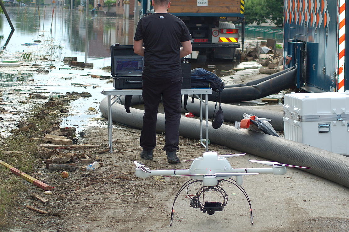
The md4-1000 Quadrocopters, which were developed by Germany-based Microdrones GmbH, are being used by Belgium’s Royal Military Academy (RMA) in the disaster area. "We’ve conducted around 20 flights over a two week period, either manually or using automatic waypoints," notes Haris Balta. The RMA development engineer carried out the mission on site. "We’ve provided the other rescue teams with damage reports, detailed maps and pictures of the disaster zone – the goal being to locate the countless landmines from the civil war." Mr. Balta, who was born in Sarajevo, has been with the RMA since 2012. The drone sorties in flooded areas have involved a tremendous effort for him as well. His work was carried out under harsh conditions, in that aid could not be provided to many areas because they were rendered inaccessible by the flooding. The microdrone UAS (Unmanned Aircraft System) was the only way for rescuers to get an overview of the situation amidst the flooding, landslides and rubble.
USING DRONES TO LOCATE LANDMINES
The region contains numerous known or suspected minefields, a legacy of the 1992 – 1996 civil war. According to a 2013 report by the Center for Mine Safety (BH-MAC) in Bosnia and Herzegovinia, the war zone contains an estimated two million landmines and unexploded shells – the former in some 28,700 locations. This translates into a landmine zone of around 1,230 square kilometers in size – a situation that poses a problem for rescue teams in the disaster zones. During the rainfall, a number of dams were breached in the environs of the village of Kopanice, which is southeast of the northeastern Bosnian city of Orasje. Pastureland and numerous minefields were inundated, and deploying rescue teams to these areas would have been too risky. It was days before people in this area received the aid they needed in order to survive. What’s more, landslides in Maglaj (a city located further inland on the Bosna River) and its environs shifted entire minefields. As a result, Maglaj’s around 25,000 inhabitants can no longer move about freely without risking life and limb.
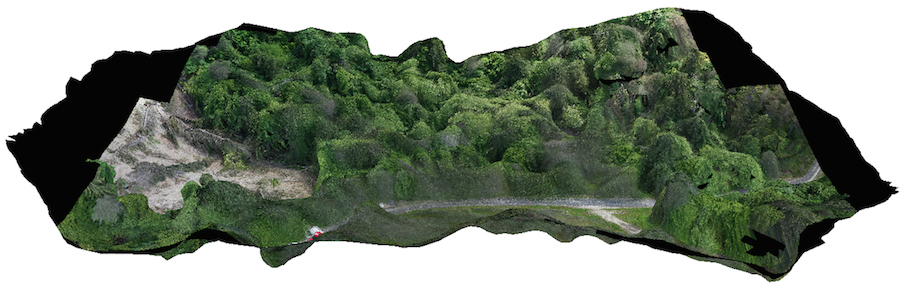
Using UAVs, detailed aerial 3D photographs were taken of the areas affected, which helped to measure how far the minefields had shifted. In the Maglaj region, mines were found up to 23 kilometers away from their original locations. In this case, airborne support provided invaluable assistance for rescue-team deployment in the disaster zone. "A two-hour drone sortie saved the rescue team three days"" the on-site B-FAST team noted.
RAPID ASSISTANCE ON SITE, IN A TIME-SAVING MANNER
Apart from helping to locate landmines, the detailed aerial photos have allowed for considerably more efficient deployment of rescue teams and have greatly eased the task of planning such deployments. The city of Orasje in northeast Bosnia was particularly hard hit by the flooding. Thousands of people lost their homes and many were cut off from the outside world. Initial attempts to pump water out of the area proved fruitless. At first, it was unclear why the water level failed to decrease, even though the pumps had been in operating for days. The Belgian military’s first aid and support team was called in to determine why this was the case. During a microdrone sortie, images captured by a high-resolution camera revealed that a dam (which also marked the border with Croatia) had been breached, and massive amounts of water were streaming out of it. Thus it turned out that all previous attempts to pump the water out were doomed to failure. It was not until the dam was repaired that the situation improved in the areas affected. Moreover, the photos taken from the microdrone revealed that the collapse of the dam was attributable to sabotage, and not to the forces of nature. Thus the photos were used by officials as evidence for the ensuing criminal case.
Less spectacular, but no less important, was the deployment of the Belgian rescue team B-FAST for the German disaster relief organization known as the Bundesanstalt Technisches Hilfswerk (THW). It was not until aerial photographs became available that rescue teams were able to deploy pumps optimally in the relevant areas. In Bosnia, the THW deployed (among other things) a High Capacity Pumping (HCP) pumping module, which pumps up to 15,000 liters per minute over a distance of up to 1,000 meters.

Haris BaltaSo many local officials and end-users have acknowledged the helpfulness of the sorties to date (which were carried out right after the flooding) that they have asked us to support the UN’s new missions as well.
AMBITIOUS EU PROJECTS INVOLVING LANDMINE-SEARCHING TOOLS
Microdrones can be used for many different purposes, in large measure thanks to their agility. But when it came to the inaccessible flooded areas, the Microdrones needed to meet very special requirements. It was essential that they be able to fly for lengthy periods and enable rescuers to operate in narrow areas on the ground. The md4-1000 Quadrocopters used in this case are easy to maneuver or can even fly over waypoints without a pilot, for up to 90 minutes at a stretch (using a special high endurance configuration).
The UAS is part of two different EU projects. Under the ICARUS project, tools were developed that are intended to help rescue teams locate survivors – including through the use of drones, as well as unmanned vehicles for deployment on the ground, and in the water. The solutions developed by the TIRAMISU project, on the other hand, are designed specifically for landmine searches. The Belgian RMA is the coordinator for these projects, in both of which the Quadrocopters have proven to be particularly useful, under daunting conditions.
Demining (searching for and disarming landmines) is a major step toward peace in the areas hardest hit by what was a very long war, and is the main goal of TIRAMISU. The populations affected will only be able to build infrastructures and create a safe environment once the extreme hazard posed by the lethal relics of the war has been neutralized. But the large numbers of mines involved and the lack of plans are making demining a lengthy process. In 2008, the UN issued statistics, according to which landmines, which can remain active for decades, are responsible for 15,000 to 20,000 deaths annually worldwide. Such figures were one of the impetuses for the Ottawa Convention many years ago. This treaty banning antipersonnel mines was signed in 1977, and by 2013 had been ratified by more than 161 nations. However, according to the 2013 Landmine-Monitor Report, there are still mines in 59 nations and a number of other regions.
THE UN IS AGAIN USING DRONES FOLLOWING THEIR SUCCESSFUL DEPLOYMENT
Having evaluated the successful deployment of German Microdrones as part of the ICARUS and TIRAMISU projects, the UN is now also using md4-1000 drones. In Bosnia and Croatia, detailed aerial photographs are again providing landmine search teams with invaluable support. According to Haris Balta, "So many local officials and end-users have acknowledged the helpfulness of the sorties to date (which were carried out right after the flooding) that they have asked us to support the UN’s new missions as well." Thanks to drones, considerably more precise and rapid assistance can be provided to storm victims, particularly in difficult to access areas or areas that are hazardous owing to the presence of landmines.