A BETTER VIEW WITH LIDAR
The team at Spatial Data Consultants is flying the Microdrones mdLiDAR3000 to gather even more details for their clients.
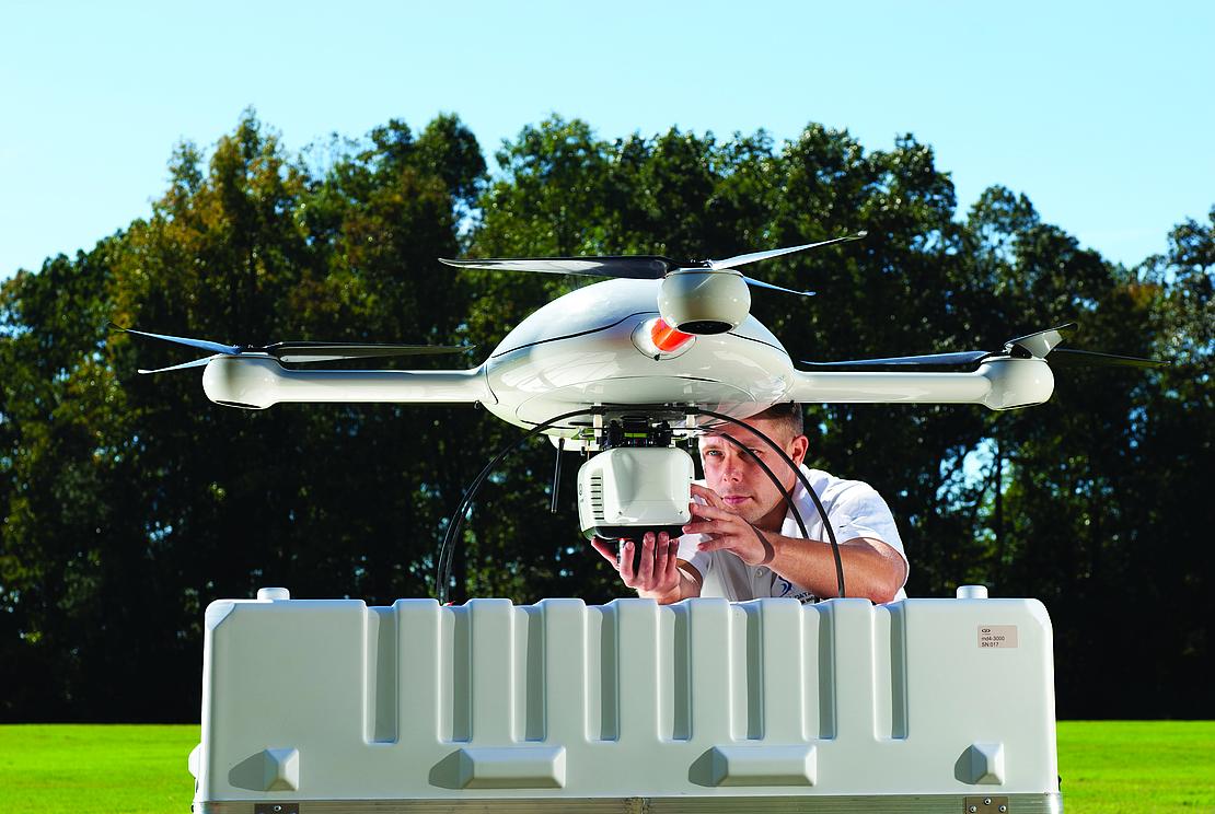
About a year ago, the team at Spatial Data Consultants decided to invest in drone technology. They knew they wanted a professional grade UAS that could deploy LiDAR, make them more efficient and provide richer data. To get started, they invested in the mdMapper1000 photogrammetry package from Microdrones, and then worked with the company to develop the LiDAR payload that is now on the mdLiDAR3000.
The High Point, North Carolina based geospatial consulting firm was the first to take delivery of the mdLiDAR3000, Director of UAS Services Robert Chrismon said, and began working with the system last August of 2018.
“Our focus was to get the LiDAR application. We bought the smaller drone to get familiar with the platform,” Chrismon said. “It gave us a system to train our pilots on as well as an opportunity to use a drone when LiDAR wasn’t necessary. But our main focus was to get into LiDAR, which is why we went with Microdrones and the integrated LiDAR payload.”
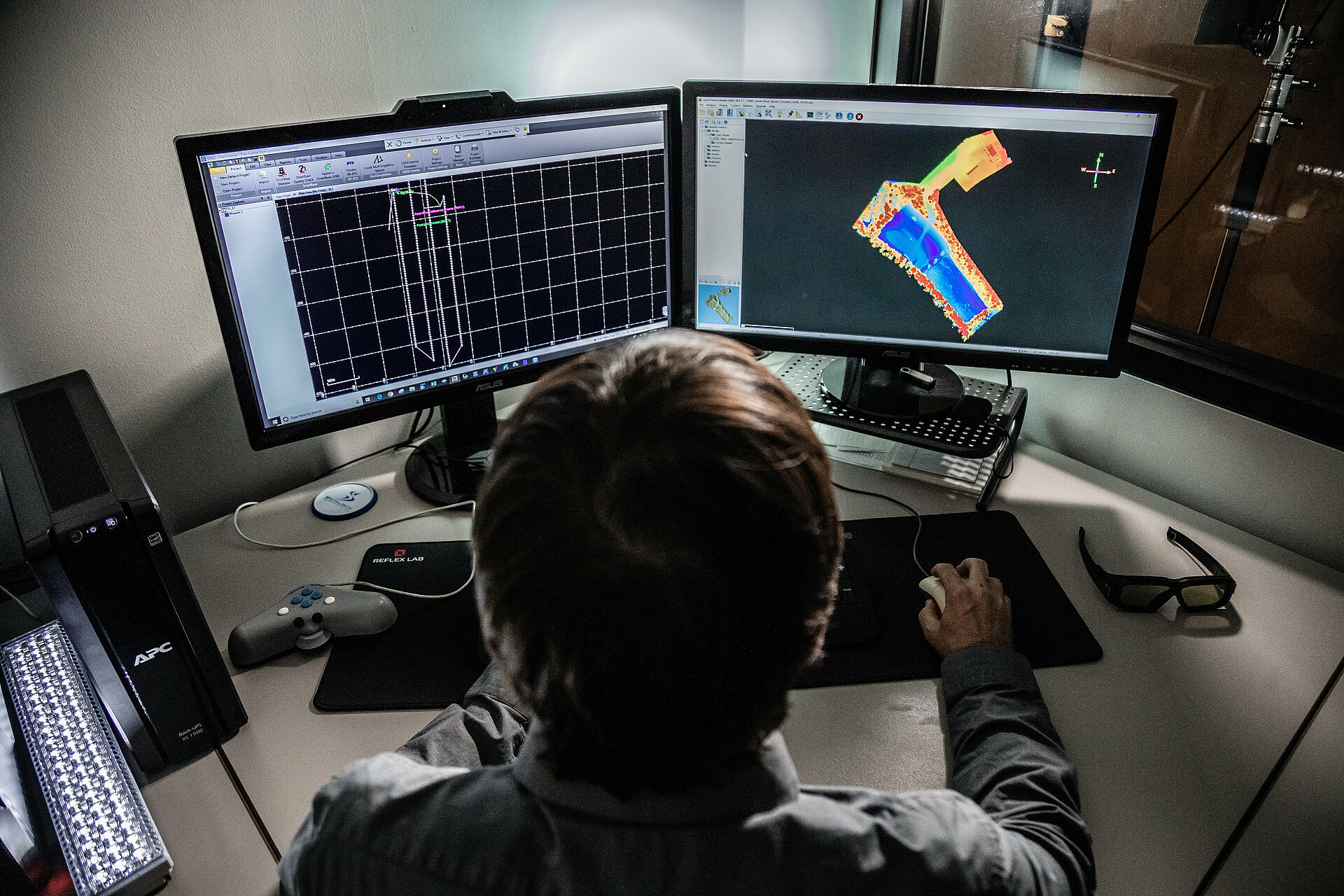
At first, the team used the system for volumetric calculations in landfills, but soon realized other applications were an even better fit, such as design surveys, Chrismon said. With LiDAR, they’re able to penetrate through vegetation, which is one of the biggest benefits the technology offers land surveyors.
“You get multiple returns with a LiDAR system that helps penetrate vegetation and get down to bare earth,” he said. “You can’t do that with photogrammetry. The drone can cover more ground than a conventional survey and get richer data. So a big part of this is the time savings and the richness of the data we get afterwards.”
The Applications
The team deploys the system at least weekly, Chrismon said, whether they have a specific project or are experimenting with new uses. They’re mostly doing topographic and planimetric mapping. The system is flying over rural areas, some wooded some not, that are anywhere from 20 to 200 acres in size.
Robert Chrismon, Director of UAS ServicesYou get multiple returns with a LiDAR system that helps penetrate vegetation and get down to bare earth. You can’t do that with photogrammetry. The drone can cover more ground than a conventional survey and get richer data. So a big part of this is the time savings and the richness of the data we get afterwards.”
Take it to the Grave
The team’s most recent project involved a historic graveyard at a local church, Chrismon said, with tombstones dating back to the late 1700s. They used the drone to survey the entire graveyard and generate a database of grave locations. The geo database makes it possible for the owners to keep track of existing lots and build a history, something they struggled with before.
For now, the company has two trained pilots on staff, including Chrismon. As they develop more uses for the technology, they may expand their UAS team, he said. Not only does the company fly their own systems, they also process all their data in-house.
The Benefits Over Other Methods
Chrismon has been working in land surveying since the mid-1990s and said conventional methods he’s used in the past are a lot more time consuming and in a lot of situations not as accurate as aerial LiDAR. Before, workers would walk an area with a ground total station and a prism, taking shots every 25 to 50 feet.
Completing surveys in wooded areas takes a lot of effort, he said, with workers having to physically carve out lines of sight to see through the woods and collect the data. With aerial LiDAR, they’re able to penetrate through tree canopies to get the information they need without having to spend time carving out sections.
“A sparsely wooded 20 acre site could take three or four days on the ground. Now we can fly and shoot the same area in a matter of hours,” Chrismon said. “Field work goes down from days to hours. You can knock out a week worth of work in a day, including planning and travel time.”
Not only can they collect the data they need faster, it’s also more accurate in most cases, Chrismon said.
“When you do a conventional survey you work on a grid and locate points every 25 to 50 feet. With LiDAR, you’re getting 30 to 80 points in a square meter,” he said. “So instead of having one point every 25 feet, you have one point every few inches. The information you can extract from that data is much richer.”
Future Uses
While LiDAR applications are the firm’s focus, the team is also looking for more ways to use photogrammetry and the md4-1000, Chrismon said. They recently invested in an inspection package from Microdrones.
“We’re looking to grow the inspection side with photos and videos,” he said. “It could be infrastructure inspection, it could be asset management, it could be monitoring environmental issues. We are eager to utilize the +inspection package for our mdMapper1000.”
Why Microdrones
When Chrismon first began looking for a system to invest in, he saw what he described as a lot of low-end toys that didn’t provide what he needed. He wanted a professional grade solution with the ability to integrate different payloads. As he worked with the Microdrones team to develop the LiDAR payload, he was impressed with how the laser scanner, inertial measurement unit (IMU), software and app that controls the interface all integrate together. The integration is smooth, which was important to him.
Chrismon also has been pleased with the level of customer service he’s received from the team at Microdrones, he said.
“We were their first customers using the LiDAR unit so we definitely worked with them more than a typical customer,” Chrismon said. “The service and responsiveness have been great. If we do have an issue, they’re quick to jump on it and give us a solution or feedback. They’re a great group to work with.”
If you're interested in making LiDAR a part or your workflow CLICK HERE for more information.