High Resolution & Efficient Drone Lidar
The mdLiDAR1000HR aaS is the next generation of industry leading drone Lidar survey equipment offered by Microdrones. The mdLiDAR1000HR aaS uses the lifting power, resilience, and efficiency of the Microdrones aircraft platform to carry a perfectly integrated Velodyne VLP-16 PUCK LiDAR sensor for increased coverage and the ability to deliver high-resolution point clouds. The system also has a fully integrated SONY IMX264 camera sensor.
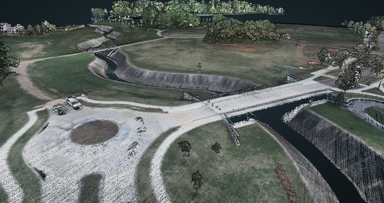
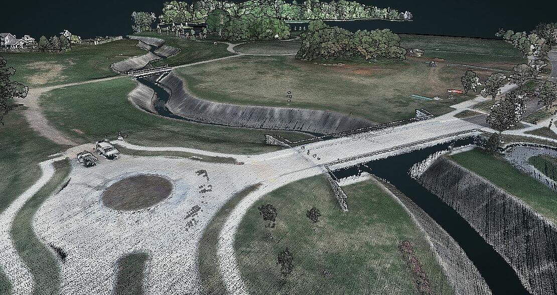
To demonstrate the high-resolution point clouds that can be created from data collected with the mdLiDAR1000HR aaS, Ross Kenney, UAS Sales and Support Lead for Navigation Electronics used the new LiDAR system to collect data at a local park under construction in Southern Louisiana. Kenney was able to perform the entire Microdrones workflow from field to finish within 4 hours to collect and process the initial data from the site.,
CLICK HERE or on the image below to view the point cloud created from his drone LiDAR survey which was also used create the CAD line work of the curb and gutter, the bridges, the paint striping, and other points of interest.
Park Project and Demonstration
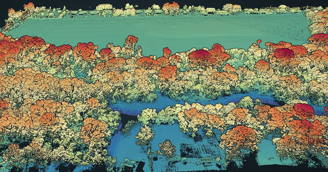
The area of interest for this survey is a newly developed park in Southern Louisiana. Since breaking ground the park has developed a new lake, a great lawn, trails, a dog park, tree plantings, as well as much of the infrastructure and utilities for future developments.
Fortunately for Kenney, the area of interest on the park site was conveniently located within 3 miles from the Navigation Electronics headquarters, allowing him to set up his base station at the office, well within the tolerance range for the distance he could fly from the base station.
“They gave me a call for the demonstration at 2:00 in the afternoon,” Kenney explained, “and by 3:00, I had my base station set up at our office. From there, I travelled to the park, and by 7:00 on the dot I had all flights finished, returned to the office, broken down my base, imported the data into mdInfinity and processed all three flights to produce the LAS files. So, four hours prior to finishing this flight or this processing, I wasn't even planning on flying. That goes to show you again, the versatility and efficiency that this system gives you.”

The Workflow
Each project was conducted using the Microdrones workflow of Plan, Fly, Process and Visualize. Mission and flight preparation details, as well as the flight parameters and data acquisition will be reviewed for each flight.
Plan and Fly: 3 Flights in less than 2 hours
The area of interest in this project was the front entrance to the park, where a new bridge, parking lot, road work, and landscape architecture had been built and the area to the south where further expansion plans in the next phase will be developed. Kenney intentionally left a small gap in the data collected since it wasn’t of interest and it helped save time in the field.
Across all 3 flights, the mdLidar1000HR aaS flew at an altitude of 50 meters, with 50% overlap at a speed of 4 meters per second leading to a point density of over 300 points per square meter.
Process and Visualize
The point cloud was created and processed through the mdInfinity software suite using the following data processing modules: Trajectory Processing, Georeferencing, and Precision Enhancement (+ noise reduction) to insure an accurate and precise point cloud. Using the mdInfinity ground classification routine, vegetation can be removed and the bare earth data can be further processed to develop digital terrain models.
The point cloud was also colorized to aid in visualizing the features captured within the data.
“After reviewing this data from the mdLiDAR1000HR aaS I can tell you this system is a game-changer,” said Kenney. “In the point cloud you can clearly see that the entire park area, all the individual homes, and how well defined the creek is. In the parking lot, even all the striping is defined. Furthermore, you can see a high level of detail over the homes and property adjacent to the park, even though I did not fly over them, but because the scanner was such a wide field of view. You could see swimming pools. You could see the lounge chairs. You could see the umbrellas. You could see the Palm trees, all the landscaping, everything.”
Line work
This high resolution data can also be used with other processing software to create line work, figure tree count, tree trunk segmentation, extract topography, and create other GIS assets from the point cloud data. To further demonstrate this, Kenney used a program named TopoDOT to help automate the line work extraction and create highly accurate representations of the bridges, curb and gutter, and the paint striping.
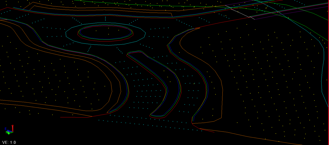
“So ultimately, if you are trying to produce a deliverable for your customers that will require any type of line work to be done,” Kenney explains, “using this transformative technology in LIDAR and especially the mdLiDAR1000HR aaS when you can start with this amount of data and clearly see well-defined all the sidewalks and the coulee and the roads and the striping and the bridges. This enables you to work off of 70, 80, 90, 100 million points, as opposed to 1500, 2000 GPS shots that might be taken by a conventional crew using a GPS base and rover.”
For more information on High Resolution point clouds and the mdLiDAR1000HR, CLICK HERE to speak with a friendly representative from Microdrones.