LIDAR OR PHOTOGRAMMETRY?
Microdrones experts explain what’s best to use, and when.
Choosing a relevant surveying/mapping system involves technologies created more than 100 years apart. Each was built on inventions that changed the world—and in one case, even affected outer space. Each is enabling precise and efficient measurement, safety and cost-saving.
The first permanent photography was “developed” over several years starting in 1822. By 1840, a French surveyor was proposing the use of photos to create topographic maps. In 1867, the term “photogrammetry” was coined.
Today, in aerial use, photogrammetry captures numerous 2D images and “stitches” them together to measure distance against a known scale, yielding a 3D color product. Photogrammetry is widely used for surveying and mapping, as well as in fields from meteorology to movie-making. But it’s time-consuming to process and can’t see through vegetative canopies.
In 1961, more than a century after that first photo was produced, Hughes Aircraft commercially introduced the laser. Soon after, the first LiDAR system began to help track satellites. Subsequent uses have literally involved aiding landing on the far side of the moon, as well as much more widespread application as a precision survey tool.
LiDAR stands for Light Detection and Ranging. It employs an active, rapidly pulsing laser to record distance via the time it takes for light to reach a surface and then reflect back to a sensor. In co-ordination with a GPS receiver, airborne laser scanners create accurate 3D point clouds representing land (topographic) or underwater (bathymetric) surfaces and elevations.
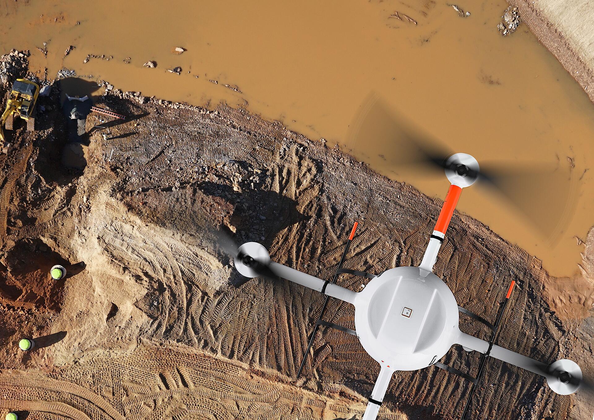
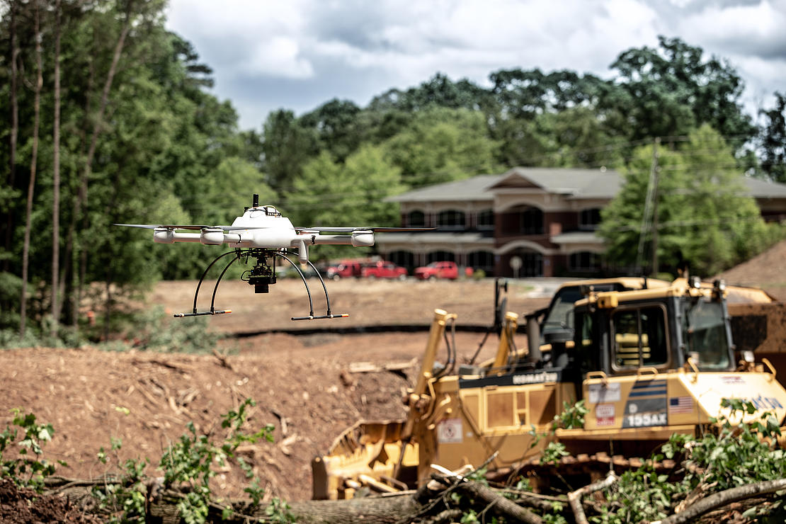
LiDAR use is surging: its global market in mapping was expected to exceed $900 million in 2019 and may grow to $4 billion by 2026, according to a report by Global Marketing Insights. Drones equipped with LiDAR can produce high-accuracy maps without putting people at risk in difficult terrain or bad weather.
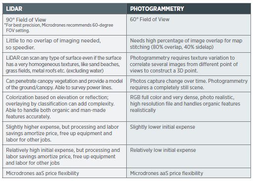
The 10,000-foot synopsis of each technology’s value goes something like this: photogrammetry is initially relatively inexpensive and offers good visual representations and sampling distance for small-area, relatively basic data projects. But photogrammetry requires extended time to deliver data. LiDAR is highly accurate, can be quickly processed and can penetrate vegetation. But LiDAR initially costs more and needs to be colorized.
However, that dichotomy is too simple at a time when drones are flying an ever-expanding array of missions with technology that’s improving across the board. Consequently, Microdrones President Vivien Heriard-Dubreuil takes a holistic view of the two technologies. “We talk about photogrammetry and LiDAR as two separate things,” he said. “But most of the LiDAR payloads have cameras in them. So, at the end of the day, when you do full colorization, you’re pretty close to photogrammetry. For us, it’s key to master both technologies.”
To add nuance and help users make the right decision, top experts from Microdrones offer their views on what choice works best, and when.
Vivien Heriard-Dubreuil, CEO, MicrodronesThe main approach of LiDAR is to get fast results, and the approach we took for the photogrammetry piece is to get fast results.
A Role for Each
But which is “better?” Frank Darmayan, COO of Microdrones, doesn’t think that’s the right question to ask. “I don’t think one technology is better than the other; they’re just different,” he explained. To make his point, he used an example from his days in the mining sector. “If you take a mining customer, they will have front-end loaders and they will have excavators, depending on the job. If you are trying to carry something for a long distance, the loader will be better. If you are trying to dig a hole, the excavator will be better. However, both can complete the job.
“It’s kind of the same with the drones you’ll use for aerial surveying,” Darmayan continued. “You can use both LiDAR and photogrammetry, but in most cases, one will be better than the other. If you are trying to survey a high wall in the mine, and you are trying to see the detail of the crack, photogrammetry will be better. If you are trying to do a volume calculation, if you are trying to see the terrain beneath the trees, LiDAR will be much, much better.”
Vincent Legrand, vice president of global sales for Microdrones, adds, “it depends on the application and also on the frequency of projects or missions.”
Legrand saw both technologies enabling increased productivity. “The job of surveyors has changed a lot in the last few years,” Legrand said. “The first thing for them was to use photogrammetry- it was an accessible tool and part of their daily process. With photogrammetry, you save time compared to traditional survey methods like sending a crew into the field to collect ground points. You gain productivity.”
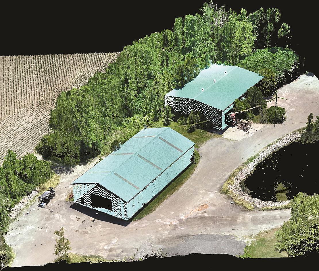
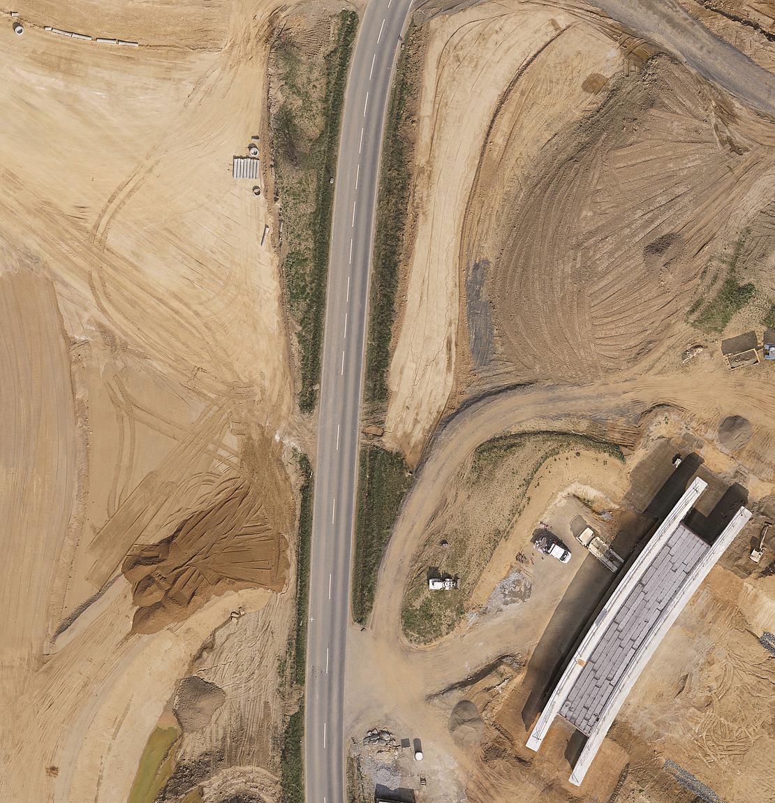
Photogrammetry can yield full-color 3D representations with accuracy of 1-4 pixels, generating point clouds by stitching together literally hundreds of thousands of images. Traditionally, it’s been used when visuals are needed, say for inspections and open-field agriculture, and for comparison over time. “High walls, where you really want to look at the details,” Darmayan said about photogrammetry’s benefits. “If you are trying to survey a construction site and you want to see the orthophotos day after day, photogrammetry will be a great product.”
Photogrammetry’s relative lack of complexity has led to broad interest from less-capital-intensive small businesses and, consequently, many manufacturers. This creates strong price competition in the drone market.
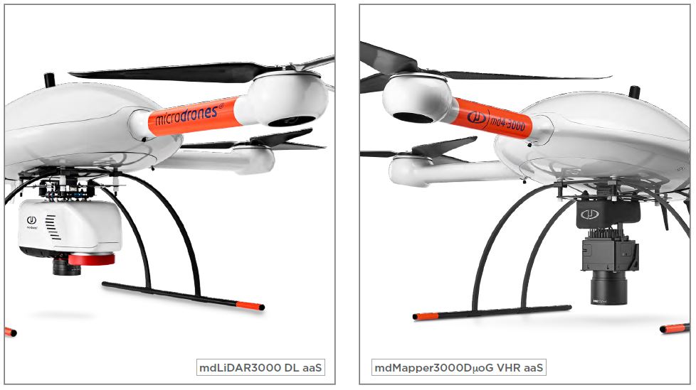
“But photogrammetry has a huge range,” Darmayan cautioned. “You can go from the Christmas gift under your tree all the way to the professional system.” The market advantage of Microdrones involves enhancing photogrammetry’s capabilities. Its mdMapper1000DG, as the acronym implies, features direct georeferencing. “When you use traditional PPK- post-processing kinematics- normally you have to put in a lot of GCPs [ground control points],” Legrand explained. “Using the DG gives you the possibility of using none or very few. This gives you a competitive advantage, to work faster and better.”
The mdMapper1000DG IMU enables corridor mapping, which also speeds up data collection and post processing, especially in the oil and gas sector. The top-line mdMapper3000 models feature a high-quality sensor that increases accuracy at distance. “If you’re trying to do a survey of a mine that’s 800 feet deep,” Darmayan said, “and you don’t want the drone to fly down into the mine- which is dangerous- with a big sensor you can stay at high altitude and still get very accurate and precise data. We have mining customers like this, with pit mines that are very deep in countries that don’t have limitations in altitude.”
Interestingly, Microdrones executives feel that LiDAR has pressed photogrammetry to step up its game. “The main advantage of LiDAR is to get fast results,” Heriard-Dubreuil said, “and the approach we took for the photogrammetry piece is to produce fast results. You have a lot of photogrammetry available on the market but we have accurate IMUs and really good integration that will allow us to be faster than the others. That’s really the main advantage of Microdrones.”
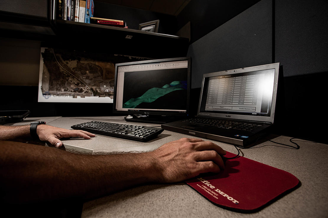
“I think the biggest misconception is that LiDAR is complicated,” Heriard-Dubreuill said. LiDAR’s intricacy, for him, is about delivering qualitative excellence. “The challenge is the quality of the raw data with LiDAR. If you don’t have the right sensors or the right parameters you will produce really bad results. Garbage in, Garbage out. But if the workflow is well done and the integration is well done, like we do, it’s much easier and faster to process LiDAR data than photogrammetry.”
Another reason LiDAR has gained popularity is its ability to extract data from situations closed to photogrammetry. “A very important point,” Legrand said. “When you survey or map in a vegetative area, you can measure the ground with LiDAR. You cannot do that with photogrammetry.”
LiDAR also is adept at measuring narrow objects. Legrand cited a Malaysian mine that had been using photogrammetry to measure pipeline use. “Photogrammetry could take three or four hours to yield data that LiDAR could generate within an hour. For them, it’s a huge gain,” he said. This need for speed is especially acute after a natural disaster, when LiDAR can deliver crucial results in a fraction of the time it would take photogrammetry.
“Even the types of surfaces you can survey matter,” COO Darmayan noted. “If you are trying to see a powerline or a complex structure like a cell tower, photogrammetry will struggle. With straight pieces of metal, grey against grey, photogrammetry will struggle. If you are trying to see water, LiDAR will give you the surface. If your only real choice is to survey at night, then LiDAR will allow you that; photogrammetry will not. You have a lot of cases where LiDAR is your best option.”
LiDAR also eases data processing. “If you are trying to get a point cloud of a certain accuracy, the raw data is about 100 times larger with photogrammetry,” Darmayan continued. “All those pictures have to be acquired, moved, processed, installed and sometimes uploaded. That’s a big cost. Whereas with LiDAR, the product you get is the end product- you don’t need raw data that is 100 times bigger than your final product.”
Topline speed and accuracy have been produced at Microdrones by its scientists continuously researching the integration of GNSS, IMU and LiDAR into turnkey systems. “That’s really our specialty at Microdrones,” Darmayan said. “That’s where we spend most of our time- in the post-processing area of LiDAR data.”
For example, the mdLiDAR1000 can produce denser point clouds than its photogrammetry mdMapper1000 counterpart and fly up to three returns, which makes it especially useful for corridor mapping and volume calculation for mining. The mdLiDAR3000DL features increased lifting power, an advanced Sony camera, the RIEGL miniVUX-1DL sensor and heavy-duty LiDAR geomatics. Accurate down to the 1 to 4-centimeter level, it’s billed as a “serious machine for serious geomatics professionals in construction, land development, engineering, surveying, research” -one that can deliver more and more accurate data in less time, with a smaller crew than either land surveyors or a photogrammetry unit.
The call for sophistication is growing, Legrand noted. “You can sell LiDAR in Indonesia, in Africa, in Latin America. If you target big mining companies, big construction companies, big engineering firms, they will need LiDAR.” As proof, Legrand noted a finding from a pre-corona trip to Sweden. “These people have been working with photogrammetry for five or six years. Now they feel it’s not enough. They want to go to the next step. The next step is LiDAR.”
Calculating Cost
When used on UAS for surveys and inspection, LiDAR, like photogrammetry, enjoys a significant cost advantage against helicopters. “You can imagine when you put a LiDAR on a helicopter, an hour costs something like three to four thousand Euros,” Legrand said. “When they use one of our LiDAR systems, they can work with a much less costly solution.”
Photogrammetry’s lower purchase price makes it attractive to entry and small companies, he continued. “It’s very accessible, which is why a lot of surveying companies and engineering firms are working with photogrammetry today. LiDAR’s price point was much higher, so a lot of people didn’t want to invest in LiDAR because they were not sure they would have enough projects to amortize it.”
But advances, including those imported from other sectors, are fostering a more supple pricing model for the technology. “You have more and more LiDAR sensors on the market that are competitive compared to cameras.” COO Darmayan agreed. “Now it can be more affordable and efficient to use a mdLiDAR1000 for a terrain survey when compared to traditional surveying methods and costs. That’s because the driverless car industry and autonomous driving have increased the demand for these sensors.
“As those sensors are mass produced, costs come down, making them much more affordable. We then integrate those sensors so we can get pre-processing about 10 centimeters, and then we can improve that with our software”
For companies with recurring business and cash flow, LiDAR’s much faster data processing time frees up equipment and staff that can amortize that initial expense. “You need to look at total cost,” Darmayan continued. “Take for example an aggregate company that’s been using photogrammetry for tile measurement. This is inefficient. They have this huge amount of data, they’ve reconstructed four to eight hours of terrain and they only need the pile…all they wanted was the volume.
“With LiDAR, there is no overlap, no re-construction. You just process the small data you collected, you get your volume, you’re done with it.”
The cost curve also is being flattened by the new Microdrones as a Service (mdaaS) program. Introduced just this May, mdaaS offers a flexible array of purchase or leasing options- “Buy It” or “Rent It” programs and new data processing solutions that include Pay Per Project or Unlimited data post-processing.
“With the program, LiDAR is affordable,” Heriard-Dubreuil added.
Taking Flight
In the end, it comes down to what the mission calls for. “If you’re trying to look at an orthophoto of day one, to day two, to day hundred, of a construction site, then photogrammetry is your solution,” Darmayan said. “If you’re looking for building, shapes and powerlines, and volume in general, LiDAR will be better.”
Either way, it’s worth considering Microdrones stable of integrated solutions. “For sure, the quality of our systems is very high,” Vincent Legrand concluded. “The engineering is also proven. The quality of the hardware is best in class, and so is the support and quality of the people. Our DNA is innovation.”
For more information on selecting drone Lidar or drone photogrammetry, CLICK HERE to speak with a Microdrones representative.