LONGER RANGE LIDAR POINT CLOUD
The mdLiDAR1000LR is a powerful drone LiDAR integrated system that helps professionals collect data from a longer range, covering more area per flight, enabling users to create and maintain digital twins of their assets and project sites. The newest member of the GE industrial drone line, the mdLiDAR1000LR combines the lifting power, resilience, and efficiency of the Microdrones aircraft platform to carry a perfectly integrated Velodyne Ultra PUCK (VLP-32) LiDAR sensor to capture ultra dense LiDAR data quickly and safely in the field and then turn it into a 3D point cloud.
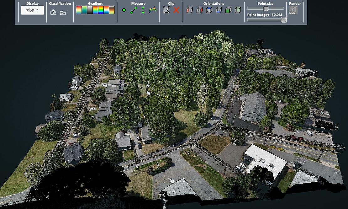
To demonstrate the capabilities of the mdLiAR1000LR, Microdrones has provided a sample point cloud from the “MEEET OUR LONGER RANGE LIDAR WEBINAR.”
CLICK HERE to open the viewer and examine the point cloud of a wooded and residential site.
Extended Range
mdLiDAR1000LR means longer range. You'll cover more ground from above. This translates to more efficiency than ever - the survey equipment, software, workflow, training, and support that you need to be productive in the field - with convenient mdaaS plans.
“The mdLiDAR1000LR increases the distance from which details can be captured,” explains Frank Darmayan, the Chief Operations Officer for Microdrones. “It can capture powerline details at 75m for distribution and 90m for transmission, effectively doubling the range of our mdLiDAR1000HR system. Flying at 70m from the powerlines, at 8m/s allows for efficient location of the powerlines with roughly 10 points per linear meter and capturing great detail of the towers.”

The Workflow
Each project was conducted using the Microdrones workflow of Plan, Fly, Process and Visualize. Mission and flight preparation details, as well as the flight parameters and data acquisition will be reviewed for each flight.
Plan & Fly
The mdCockpit application is used to begin flight planning and is then verified in the field upon closer inspection of the project. Upon completion of flight planning, the mission can then begin and the user can choose to autonomously fly the project.
The data from this site was collected in 1 flight of the mdLiDAR1000LR, flying at a constant flight altitude of 80 meters at a speed of 4 meters per second. The duration of the flight was approximately 17 minutes with 60% LiDAR sidelap and a field of view of 90°.
One of the mdInfinity data processing modules available to use in the field is trajectory quality control which can confirm the validity of the trajectory data. This module exports a simple detailed report including the Mission Duration, the Number of Events, IMU continuity check, or Base Station information amongst other information and details.
Also, while in the field, the LiDAR coverage preview module from mdInfinity was used to perform the validation of the point cloud datasets. The LiDAR Coverage Preview quickly generates a decimated point cloud for a fast baseline to validate the quality. However, it’s not a fully Georeferenced point cloud.

Process & Visualize
The point cloud was created and processed through the mdInfinity software suite using Trajectory Processing, Georeferencing, Precision Enhancement, Colorization and Ground Classification. Using these mdInfinity data processing modules, vegetation has been removed and the bare earth data can be further processed to develop digital terrain models.
The Main Advantages
The mdLiDAR1000LR system also provides a higher level of detail and better canopy penetration thanks to the large 90° horizontal LiDAR field of view. Due to this classification routines can be performed with better precision than with point clouds with a lower density.
Data processing modules applied in mdInfinity create a unique layer per layer calibration process to enhance point cloud precision along with the ability to filter LiDAR data for point cloud quality enhancement resulting in best-in-class point cloud accuracy and precision.
If you would like to speak with one of our professional representatives about the mdLiDAR1000LR CLICK HERE.