Drones as a Service: The Top Drone LiDAR and Photogrammetry Surveying Purchase Options

Everything you need to do drone surveying the right way, with convenient packages and payment options.

أصبحت أعمال الجغرافية المكانية أكثر سهولة وأقل تكلفة.

تسهل Microdrones على المحترفين البدء في العمل من خلال توفير كل ما يحتاجون إليه لاستخدام طائرات بدون طيار مخصصة لأعمال المسح المعقدة.


ما المقصود ببرنامج mdaaS؟

لا تعتبرنا شركة طائرات مسيرة.

حيث يسعى برنامج mdaaS لتمكين العملاء من نشر الحل الكامل الذي يقوم على استخدام الأجهزة والبرامج باعتبارها أحد الخدمات (البرمجيات كخدمة والأجهزة كخدمة)

تتيح Microdrones إمكانية الوصول إلى أحد الحلول البرمجية المقترنة بشراء أو استئجار معدات المسح.!

أولًا دعونا نحدد بعض الشروط.

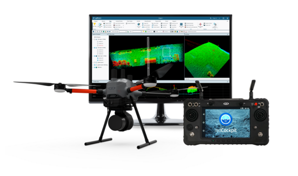
Complete mapping solution offered by Microdrones composed of Survey Equipment and Data Processing modules fully adapted to that Survey Equipment.

Hardware

Software

The necessary equipment to gather Data using a UAV. It includes the drone, the payload and Microdrones proprietary mdCockpit mission planning and control software. Data collected with the survey equipment can be processed exclusively within mdInfinity.

Any available Software module which can process and facilitate the analysis of data through mdInfinity Software platform.

CLICK FOR EXAMPLES

Unlimited access to basic software (trajectory processing and geocoding) Owner pays annual software and firmware maintenance fee. Ask for details.

Subscription processing capabilities, available in 12 month unlimited or 12 month explorer options.

Microdrones delivers access to our software solution with the purchase of Survey Equipment included in the fee. Clients retain full maintenance and upgrade responsibility.

For customers that need highly specialized data processing that is not covered by our existing modules, the mdInfinity team will work with you on special projects.

Yearly UAV & Payload maintenance for your drone survey equipment.

عملية الاختيار

1
Choose your
integrated system

Example system

i.e. mdLiDAR1000HR

2
Choose how to pay for your Survey Equipment
Buy It!

You retain full maintenance and upgrade responsibility.

OR
Traditional
Purchase

Unlimited access to basic software (trajectory processing and geocoding) Owner pays annual software and firmware maintenance fee. Ask for details.

3
Choose your subscription plan for data processing and analytics
EXPLORER

Process collected data and points within a budget. Recommended for those who fly up to 10 times per month.

OR
UNLIMITED

Unlimited processing of the data you collect. Recommended for heavy users who fly more than 10 times per month.

SUBSCRIBE!

LiDAR: Data Processing Plans

Everything you need to do drone LiDAR and surveying the right way, with convenient packages and payment options.

BASIC USER

Produce standard, geocoded pointcloud deliverables.

$1,250$1,570€1,120$1,000$1,260€890 /MO
Data Allowance up to
Explorer
Unlimited
Data Collection Time: Unlimited
Total Points: Unlimited
Data Collection Time: 200 min
Total Points: 560 Million
PRO USER

Produce refined pointcloud deliverables.

$1,670$2,090€1,485$1,250$1,570€1,120 /MO
Data Allowance up to
Explorer
Unlimited
Data Collection Time: Unlimited
Total Points: Unlimited
Data Collection Time: 200 min
Total Points: 560 Million
WORKING WITH MANY PAYLOADS OR SYSTEMS?

For multiple payloads or systems, fleet management options are available.

Cloud Data Storage*15 GB45 GB30 GB90 GB
Easy Integrated workflow
Project Dashboard
Onboarding process
Online Support
Coverage preview
LAS viewer (Sensor data and flight trajectory)
After Sales Boresight CalibrationAdditional Tokens1 per year Included
Single Base Trajectory Processing
Geocoding
Strip adjustmentAdditional Tokens
Precision Enhancement (Smoothing & Outliers)Additional Tokens
Point Cloud Direct ColorizationAdditional Tokens
Ground ClassificationAdditional Tokens
FORMapAdditional TokensAdditional Tokens

Pricing valid for new purchases only.
*Additional storage available upon request for the next 15 GB, 30 GB, 45 GB or 90 GB, respectively, per your plan.

Working with many payloads or systems?

For multiple payloads or systems, fleet management options are available.


Photogrammetry: Data Processing Plans

Everything you need to do drone photogrammetry and surveying the right way, with convenient packages and payment options.

BASIC USER

Produce cm level accuracy trajectory for your processing.

$1,000$1,260€890$670$840€600 /MO
Data Allowance up to
Explorer
Unlimited
Data Collection Time: Unlimited
Data Collection Time: 200 min
WORKING WITH MANY PAYLOADS OR SYSTEMS?

For multiple payloads or systems, fleet management options are available.

Cloud Data Storage*15 GB45 GB
Easy Integrated workflow
Project Dashboard
Onboarding process
Online Support
Single Base Trajectory Processing
FORMapAdditional Tokens

Pricing valid for new purchases only.
*Additional storage available upon request for the next 15 GB, 30 GB, 45 GB or 90 GB, respectively, per your plan.

Working with many payloads or systems?

For multiple payloads or systems, fleet management options are available.