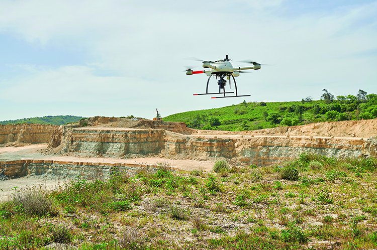
CHANGING QUARRY SURVEYING FOREVER
Aerisurvey recently undertook a marathon series of surveys using the Microdrones mdMappper1000DG.
by Peter Gutierrez
As seen in the March/April 2021 Issue of Inside Unmanned Systems

From the beginning, we wanted to acquire a Microdrones system,” said Nuno Santos, Founder and CEO of Aerisurvey. Since its creation in 2017, one of the Portuguese company’s core values has been to provide only the best possible data, so going with Microdrones was a no-brainer. “With Microdrones we get maximum quality and unprecedented reliability,” Santos said.
As recently as 2013, up-and-coming geologist Santos was still employing traditional methods for quarry surveying, typically involving the use of a total station- a combination electronic theodolite and distance meter. “I remember one very demanding quarry, about 30 hectares in area, with numerous embankments and a lot of variations in altitude. We had to set up 14 different total station bases and it took us three weeks to finish the job. Today, with our Microdrones system, we can do that same job in one day, and we get immensely superior results, with a level of detail impossible to achieve with traditional methods.”
Nuno Santos, Aerisurvey Founder and CEOIf we had to extract the same density and quantity of data through classical methods, we would quickly reach an unbearable cost for any company.
A Massive Survey Project
Aerisurvey recently completed work on a major project entailing drone-based surveying at 21 quarries in 60 days. “The timeline was extremely short and the pressure to deliver the results on time was intense” Santos said. “The project involved Aerisurvey working with several other firms, all doing different tasks, including a government component, so it was imperative that everything go according to plan.”
“Incredibly, Santos carried out the entire series of photogrammetry surveys virtually single-handedly, acting as UAV pilot, operator and data specialist. “It was the winter holiday season,” he explained, “and we couldn’t be sure that a larger team would be available throughout operations, so I performed the mission myself, surveying all 21 quarries, editing the raw images based on a specific chromatic profile, processing the data, extracting the topography, and reporting and delivering the results.”
Aerisurveyʼs marathon survey project delivered a raft of detailed data, including orthophotography, DSM, DTM, contour maps, ground points showing different densities, individual records for each GCP, point cloud, 13 ready-to-print maps, a full 3D model, aerial videos and an A0 poster for each quarry on fine-art photographic paper.

Why Microdrones is Better
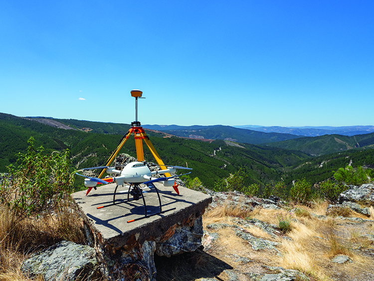
“For this kind of work,” said Santos, “having a system like the mdMapper1000DG from Microdrones is a must. Ours is equipped with the Sony RX1R II with 42.4 megapixels, paired with a custom, light-weight, vibration-free, nadir mount.
“Normally, one or two flights are enough to cover a typical quarry,” he said. “We generally set a target resolution [GSD] of 2.5cm/px, and that allows us to extract the highly detailed topography, and we can give our client a great record of the actual conditions.”
Comparing the results obtained with the Microdrones system against those delivered by traditional means is practically impossible, said Santos: “We are looking at data that is simply incomparable. If we had to extract the same density and quantity of data through classical methods, we would quickly reach an unbearable cost for any company.”
Safety, of course, is a fundamental concern in mining and quarrying operations. Here again the UAV-based solution stands far above traditional surveying methods, “especially in quarries and open-pit mines,” Santos said, “with locations that are difficult to access and/or present a high risk of landslides, close to high embankments, close to ongoing operations, close to basins and settling ponds, etc. So, if we add the safety issue and the amount of geographic data that can be produced through an aerial survey, it makes the comparison almost meaningless. The discrepancy in survey production time, and in the quality and quantity of the data obtained is just too great.”
DG Function Takes the Cake
Of all the mdMapper1000DGʼs features, Santos said the most impressive is its Direct Georeferencing. This highly efficient method for linking aerial images to their geographic positions on the Earthʼs surface works by measuring the true 3D coordinates and orientation angles of any sensor. DG thus allows for direct map production, delivering greater accuracy than traditional aerial triangulation, RTK and PPK. “The DG module is the Applanix APX-15 UAV DG,” said Santos, “with a survey-grade GNSS receiver and a precisely calibrated IMU for mapping.”
The reliability of Microdrones systems is well known in the industry, and it was one of the main reasons that impelled Aerisurvey to become a Microdrones customer. “Also, you have this great simplicity of construction and use,” Santos said, “which I consider the greatest sophistication. We are now using the mdMapper1000DG in 90% of our work, but it’s really about the complete Microdrones system. From planning to execution and data processing, everything is included within the same system, and this greatly improves the workflow.”
The Future is Now
“Over the past decade, drones have experienced an incredible exponential evolution,” said Santos. “In quarries, I believe this type of service will soon be standard in most operations. The advantages are already immense. As we move forward, we will see an easier and more fluid integration of data, so that more technicians are able to work and manipulate the data to its fullest. It is not difficult to visualize in the coming years drone systems being centralized in the largest quarries, with remote parameterization of the areas to be mapped.
“For Aerisurvey, whether we’re operating in quarries or open pit mines, or doing surveys of urban areas for licensing, registration, forest and rural areas, tourism projects and volume calculations, our Microdrones system has become an essential and crucial tool in our operations.”
For more information on adding Microdrones integrated systems to your workflow, CLICK HERE to speak with one of our professional representatives.