
LONGER RANGE LiDAR & 26MP CAMERA ALL IN ONE, TO COVER MORE GROUND
The latest LiDAR offering in the GE industrial drone line from Microdrones can cover a lot of ground.
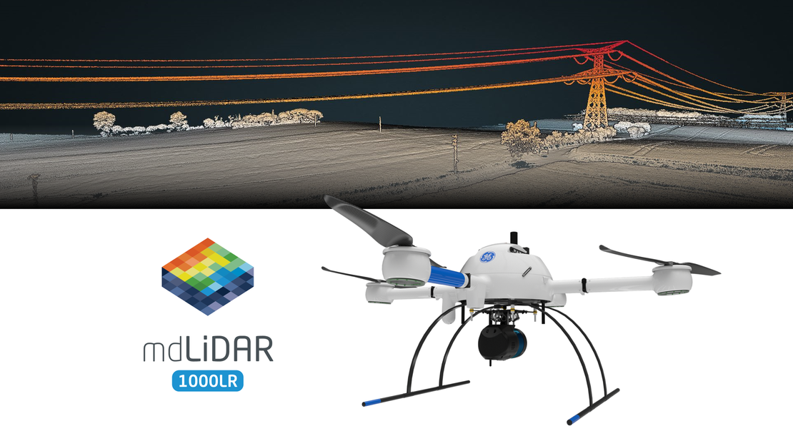
The new mdLiDAR1000LR features longer range LiDAR and a 26-megapixel camera capable of capturing images so detailed that it might look like the drone actually hovering at 200 feet was just 20 feet overhead. High point density and large-area coverage capabilities can boost productivity and accuracy.
Part of the newly launched GE industrial drone line, the mdLiDAR1000LR debuts at a time when applications for drone LiDAR are growing across many industries for a variety of tasks, like digital twin creation and maintenance, corridor mapping and construction site monitoring.
“It's been a pretty exciting year so far between the mdLidar1000HR release earlier this year, which has been a success, the introduction of the GE industrial line and now the mdLiDAR1000LR,” said Robert Chrismon, marketing manager and voice of the customer for Microdrones.
It’s an end-to-end solution combining the drone, LiDAR payload, a fully integrated LiDAR processing and photogrammetry software workflow, and world class support to consistently that promises to provide quality deliverables.
Built to last
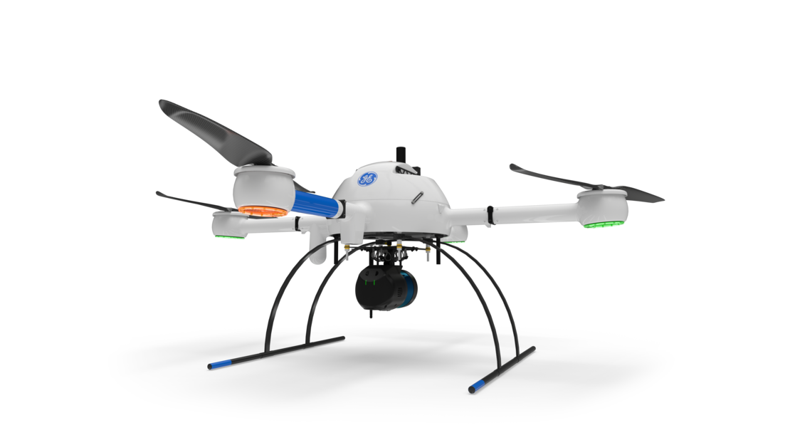
The mdLiDAR1000LR is built on the md4-1000 version D platform that might look familiar to Microdrones customers, but boasts some valuable tweaks and upgrades – not to mention the new blue GE decals.
There are two blade props instead of three to make it easier to stand the drone on the ground when the arms are turned down. Previously, the drone with the three prop-blades needed to be elevated to keep the props from touching the ground with the arms are down.
The md4-1000 version D features the familiar heat and rain resistant body with the sturdy carbon fiber housing, along with the GNSS receiver for aided navigation for manual and automated flight. The mdflight navigation controller allows for stable flights for precise results.

From an operational standpoint, new features include:
- A new motor and electronic speed controller (ESC) combination. The ESC essentially is responsible for sending energy to the motors to have them spin up and control RPMs.
- “With the new combination of motors and the electronic speed controllers, we have a measured 10% increase in efficiency that was bench tested and then also flight tested, which led to additional flight times,” Chrismon said. Times could vary depending on environmental factors like elevation and temperature.
- LED lights. Efficient LED light rings make it easier to see the drone in the sky, with orange to identify the front arm and green lights on the other three. Color schemes can be configured to comply with international requirements.
- Remote ID enabled. Akin to a digital license plate, Remote ID allows the FAA and law enforcement to find the control station if a drone appears to be flying in an unsafe manner or where it is not allowed to fly. Remote ID is in the process of being rolled out in the European Union and could be in place in the United States in 2022.
- Ground collision avoidance. Uses the same ground distance control module on the front arm, which is its own dedicated LiDAR unit. “If you're in a waypoint mission and the system comes within five meters of an object, whether it's a treetop, a building or other object, it's going to more or less assume that it's too close to something that it shouldn't be, and it's going to stop the mission,” Chrismon said. At that point, the pilot would fly the drone out manually and reprogram the mission.
- mdRC 5.1 controller. The updated controller now charges via a USB port. A scroll wheel has replaced three buttons on the right side of the remote for menu selection. A new red button on the upper right side of the remote replaces a toggle switch to start and stop the motors. “Sometimes out in the field, it's hot and sweaty, you're fingers get slick and it's hard to grab that toggle switch,” Chrismon said. “Having the button is going to add for an ease of use in the field.”
Other improvements on the version D model include updates to the landing gear and housing for the small LiDAR unit, and new integrated locks to the batteries.
Robert Chrismon, PLS, Marketing Manager, Voice of the CustomerWith the new combination of motors and the electronic speed controllers, we have a measured 10% increase in efficiency that was bench tested and then also flight tested, which led to additional flight times.
Packing a punch
The “LR” in the new mdLiDAR1000LR name stands for “longer range.” A complete solutions that has a total takeoff weight at just more than 14 pounds packs quite a punch.
The LiDAR sensor is the Velodyne Ultra Puck VLP-32. Also perfectly integrated is the new Microdrones assembled camera with a 26-megapixel sensor and a 25-millimeter lens. Georeferencing is handled by the APX 15.
The software is the tried-and-true mdCockpit and mdInfinity from Microdrones, while a flight performance app estimates flight times and voltage. System accuracy is four centimeters RMSE for the LiDAR point cloud; for photogrammetry, it’s two to three pixels horizontal and three to four vertical. The system can operate in conditions as cold as 14 degrees in the winter to as warm as 104 degrees in the middle of the summer, with flight times of up to 35 minutes.
Once in the air, coverage area is impressive. For instance, flying at 400 feet with a field of view of 90 degrees for LiDAR collection can cover 297 acres. This allows for quick acquisition of high density and accurate LiDAR, even over the wider coverage area.
Improved image acquisition enables compatibility with streamlined point cloud colorization and FORMap data processing modules within the mdInfinity platform.
Each LiDAR channel of the mdLiDAR1000LR also is boresight calibrated to improve data consistency and provide a reduced Standard Measurement Uncertainty.
There is a bit of a trade-off with the 26-megapixel camera on the mdLiDAR1000LR when compared to the HR model. While being able to capture higher resolution images with the 26 megapixel sensor, the new LR version has a smaller field of view for full colorization.
“The 25-millimeter lens works well for not introducing a lot of distortion, like a wider lens would, so that's a little bit of the trade-off,” Chrismon said. “We have better imagery, but not quite the same field of view as we did with the HR.”
The level of detail for images from high altitudes is where the LR stands out. Colors are brighter and definition lines are crisper. For instance, from more than 300 feet, you can still get a detailed view of cracks in the asphalt on a roadway.
Making a difference
Oil and gas. Mining. Forestry. Highway construction. Precision agriculture. Planning, leveling and excavation.
The mdLiDAR1000LR can make a difference for professionals across a multitude of jobs, both in terms of data collection and generation of geospatial deliverables. From surveying to mining to construction, the mdLiDAR1000LR can streamline workflow while helping to complete more surveys, see more detail, optimize mining volume analysis and maximize construction site monitoring.
Customers also can take advantage of the flexibility offered through Microdrones as a Service (mDaaS), which offers options to buy or rent the drone, survey equipment, software, workflow, training and support. It’s all about what option best suits each situation.
“A longer-range LiDAR combined with a photogrammetry grade camera - all in one - to cover more ground, meaning more efficiency than ever for our customers,” Microdrones CEO Vivien Heriard-Dubreuil said.
For more information on the new mdLiDAR1000LR, CLICK HERE to speak with one of our friendly representatives.