
Flying the Great Pit
European engineering consultancy company Sweco is deploying the mdLiDAR3000DL aaS to monitor the Falun Mine, once the world’s largest copper producer, to identify movement or settlements that could lead to a collapse.
by Renee Knight
As seen in the December 2020/January 2021 Issue of Inside Unmanned Systems
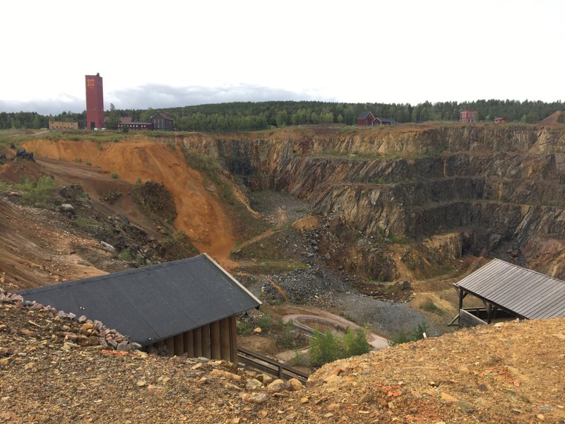
Falun Mine is one of the oldest mining areas in Sweden, and in its heyday was the world’s largest copper producer. In the 1600s, a lack of structure in the underground tunnels caused part of the mine to collapse, creating a large hole that’s become known as the Great Pit. The mine is now a tourist attraction, drawing visitors interested in exploring this important piece of Sweden’s history.
There are still underground shafts in the mine that date back to the 1400 and 1500s, and they are slowly collapsing because of rain-water, vibrations from the surrounding roads and other factors. Sweco, a European engineering consultancy company, has been tasked with monitoring the pit to look for movements that would be missed in a visual check.
Sweco began this project about four years ago, deploying a UAS equipped with a camera to collect data and then processing a photogrammetry point cloud of the mine to compare to natural land surveys, said Johan Larsson, a surveying engineer for Sweco. They found this method didn’t provide enough accuracy to show the smaller changes in the flat area of the pit, and it became clear they needed to upgrade to LiDAR.
Johan Larsson, Sweco Surveying EngineerWe can solve LiDAR scanning for clients in less than a week with the mdLiDAR3000 DL aaS. That was impossible before
Last August, they flew the steep terrain of the pit again, but this time with a mdLiDAR3000DL aaS from Microdrones—and came away with a much better result.
“They want to see if an area is starting to collapse so they can take some action and fence in the area to keep people out. With this system, we can get high accuracy point clouds in dangerous areas,” Larsson said. “There are parts of this mine that are very difficult and dangerous to reach for a land surveyor. If he has to climb around the area, that’s impossible to do. We’re now able to collect data in areas we couldn’t get to before.”
Creating a Better Picture, Safely
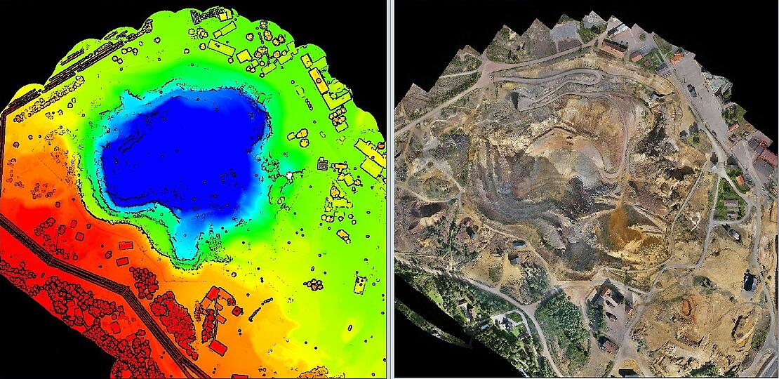
After a day of flying the mdLiDAR3000DL aaS, the team obtained the data needed to create an orthomosaic with an overview picture of the entire pit— something they couldn’t achieve with traditional surveying methods, said Rikard Svall, chief survey specialist for 5D Teknik, the distribution partner for Microdrones in Sweden. The security risk to personnel is just too great.
“This project is more or less impossible to do with traditional methods,” Svall said. “This is an open pit mine so it’s very dangerous to be inside the actual pit or next to the pit. It’s basically the safety of the workers. No one wants to send their staff on missions where they could die if the walls start caving in.”
Sweco will continue to fly the mdLiDAR3000DL aaS over the Great Pit for years to come, area manager Mattias Jansson said, with the next flight expect-ed to take place in a year or two. The point clouds created during each flight will be compared to previous flights, allowing the team to look for movements or settlements in the earth that indicate sinking. Using LiDAR instead of photogrammetry point clouds offers “the best comparison of the datasets” and much better accuracy.
If any issues are detected, Larsson said, the client will be notified so they can continue with visual inspections and take any necessary action, enhancing safety in the area.
Why Microdrones
Jansson first saw the Microdrones system at a conference, and decided he wanted to learn more. He and a colleague traveled to Germany in March for a demonstration, and both were impressed. They knew the mdLiDAR3000DL aaS would not only be beneficial for the challenging Falun Mine flights, but for a variety of other projects as well.
Along with the LiDAR payload, the surveying drone offers greater performance than other systems, Larsson said, noting “you can collect a lot of data during your flight.” But the fact it’s a complete solution is probably the biggest benefit, Jansson said.
“It’s a fully integrated system, so you get both the UAV and the LiDAR,” Larsson said. “With other manufacturers, you can buy a good laser scanner, but you don’t get the UAV. You have to buy that separately. Now, we have one integrated system, and if we have an issue with the LiDAR or the UAV, full support is avail-able from Microdrones. That’s a really good value for us.”
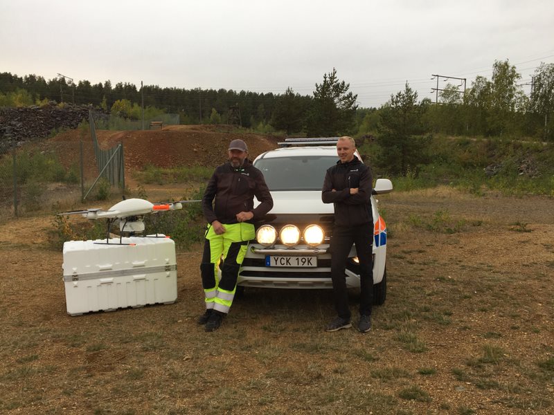
And the support they’ve received has been excellent, Larsson said, with members of the Microdrones team traveling to Sweco over the summer for training. Any questions they have are answered quickly, and they’ve found distributor 5D Teknik to be a huge help as well. Svall was even on site for the Great Pit flights.
“We wanted to stand next to them when they were flying this project so we could help if anything special happened or answer any questions that came up,” Svall said. “And they had a timeframe of when they could fly. They tried to fly early in the morning because a lot of visitors come to look at the mine around lunch time. I was there to help speed things up if something happened. Instead of telephone support it was physical support.”
Other projects
Sweco is also deploying the mdLiDAR3000DL aaS for a variety of other projects, including road surveys, producing a terrain model of a railroad corridor with less than 2 cm accuracy, and flying power stations and new power line corridors.
The mdLiDAR3000DL aaS provides the accuracy needed for these projects, and also is easier and faster to process than photogrammetry point clouds, Larsson said. And not only is it quicker to get la-ser scanning capabilities to clients via the surveying drone, it’s more cost effective than a helicopter and more efficient than traditional surveying methods. It’s also more environmentally friendly.
“We can solve LiDAR scanning for clients in less than a week with the mdLiDAR3000 DL aaS. That was impossible before,” Larsson said. “In the past we had to hire helicopters to do this kind of laser scanning, and that could take a long time. Now we have an electric powered UAV flying our LiDAR instead of a helicopter using jet fuel, so we’re using an eco-friendly method to quickly collect the data.”

If you're interested in putting the mdLiDAR3000DL aaS to work, CLICK HERE to contact a representative from Microdrones.