NOW AVAILABLE ON
YOUTUBE AND MDTV
DOWN TO EARTH PROJECT 14: Land, Sea, And Air
Down to Earth, a surveying reality series shows how real surveyors collect data and turn it into real deliverables, despite challenging conditions, rugged terrain and lurking dangers.
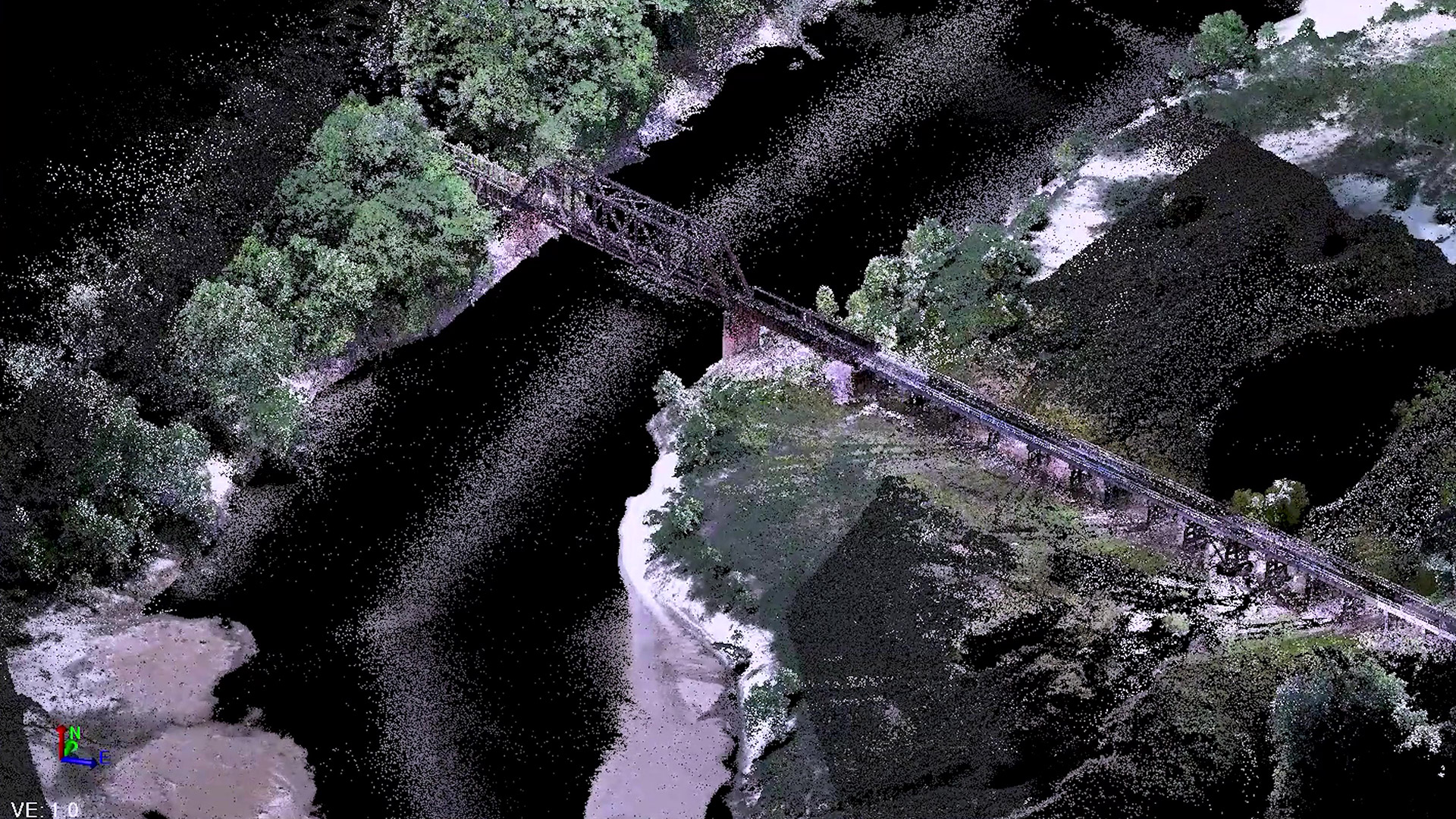
The Pearl River is a vital source of drinking water for the city of Jackson, Mississippi, but it can also cause flooding and pose a threat to the community. The Mississippi D-O-T has partnered with Tice Engineering to survey 150 acres surrounding the Pearl River, examining flood zones and inspecting bridge scour to enhance safety measures.
In these next episodes, see how Tice Engineering will deploy state-of-the-art technologies to survey 150 acres surrounding the Pearl River in Jackson, Mississippi. The team will use drone Lidar from the air, terrestrial scanning on the ground, and hydrographic scanning under the water to create a highly detailed 3D surface. The survey will focus on inspecting bridge scour and examining flood zones, providing valuable insights to the Mississippi D-O-T.
Watch Episode 1 Below
In this first episode of Land, Sea, and Air, the Tice Team deploys a Z-Boat to scan under the water and around the bridge abutments, while the mdLiDAR1000HR scans the entire area from the air. By using drone technology, Tice Engineering aims to improve safety and productivity during projects like the survey job on the Pearl River. According to Chuck Snow, the Eastern Sales Manager for Microdrones, the mdLiDAR1000HR can help complete projects quickly and accurately.
Ryan Tice, the President of Tice Engineering, recognized that new surveying technology would set his business apart and enable his team to complete surveys more efficiently and safely. “We’ll be using drone LiDAR from the air to collect data for the entire site, terrestrial scanning for under the bridges, and hydrographic scanning under the water to capture the bridge abutments and foundation under the water,” explains Tice. “The goal will be to combine the data from all three systems to create a fully developed three-dimensional model that the DOT can use to create a model and look for river scour.”
Watch Episode 2 Below:
In the second episode of our surveying series, Tice Engineering adds terrestrial scanning to their technology mix to capture points under the bridge while the mdLiDAR1000HR continues to fly above the full site, completing the project. Matthew Jones, Professional Surveyor at Tice Engineering, highlights the benefits of using the terrestrial scanner to capture all the structure below the bridges in the flood plain, while the drone collects data on bridge decks, railings, and other infrastructure.
Alos, the uneven and sandy terrain at the Pearl River survey site poses a safety risk for the Tice Engineering crew. However, by using the mdLiDAR1000HR drone to collect data of the entire site, the team can avoid traversing the entire area and only needs to access the bridge areas for terrestrial scanning. Matthew Jones explains that the drone technology helps the team complete the project efficiently and without risking harm. The mdLiDAR1000HR allows the team to collect accurate and detailed data of the entire site from the air, making it an indispensable tool for surveying projects.
WATCH EPISODE 3 Below
For the 3rd episode, the Tice Team heads back to their office to process the data collected from all three surveying technologies. Their goal will be to combine the LAS files from the Z boat, the Terrestrial scanner, and the mdLiDAR1000HR so they can build one complete surface model of the entire project for the Mississippi Department of Transportation.
Colt Ratliff, VP, Survey Manager at Tice Engineering, acknowledged the drone Lidar helped merge the entire survey project. “The mdLiDAR1000HR helped us access the entire river area, much easier than conventional topographic survey methods,” he said. “The river stage is always a major concern, especially with the water levels. This technology ensures we get data from high water, low water, and all the ground cover that’s exposed at that time.”
About Tice Engineering
Tice Engineering, Inc. is a multi-disciplined engineering firm that is dedicated to providing quality engineering and surveying services to both private and public entities in virtually every industry and/or governmental system.
Tice Engineering provides services for a variety of clients and projects, ranging in size from small parcels to coastal restoration and diversion projects, natural disaster recovery and rehabilitation, water/sewer infrastructure, highway design, port infrastructure, military installation projects, commercial/residential developments, and traffic signalization.
Microdrones and GeoCue have joined together to bring geospatial experts the very best in drone surveying equipment, geospatial software, workflow, training and support for high accuracy LiDAR and drone mapping. With TrueView drone LiDAR and imagery sensors, LP360 point cloud data processing software, and fully integrated systems from Microdrones, we are the leader in LiDAR mapping processing, able to meet customers where they are in terms of technology adoption, budget, and resources.
To learn more about our full portfolio of aerial surveying equipment and software, schedule a meeting with one of our sales managers today.