
Thompson Engineering used the mdLidAR1000HR and the mdMapper1000DG to survey the USS Alabama Battleship Memorial Park and create a digital twin. See how they plan their mission, collect data, and overcome many challenges in this 3-minute drone surveying case study.

WORLD WAR II saw the Battleship USS Alabama kicking butt in the North Atlantic and South Pacific and leading the victorious American Fleet into Tokyo Bay. Today, the beautiful ‘Mighty A’ is permanently moored at USS Alabama Battleship Memorial Park. A point of pride for the city of Mobile, the park welcomes hundreds of thousands of visitors every year.
Preservation and maintenance of the Mighty A is a priority, and that’s why the park has brought in the professional surveying team from Thompson Engineering. The team is using drone surveying equipment from Microdrones to create an orthophoto of the site and a digital twin of the Battleship.
Adam McCullough, Survey Technology Lead, Brad Busby, Survey Team Lead, and Cody Floyd, Surveyor PIC, make up the Thompson crew. These folks have done a lot of surveying in their time, but a full-blown battleship is new territory.

The park comprises more than just the USS Alabama. A complete indoor and open-air museum complex, the Submarine USS Drum and many other historic vehicles, war memorials and a large recreation area are to be included in the survey. Using conventional techniques, it might take weeks to do what Thompson is hoping to accomplish in two days.
First up is a LiDAR survey of the battleship. The mdLiDAR1000HR collects data at an altitude of 60m, well above the highest point on the battleship. The team is curious to see what the Microdrones system can make of this nautical marvel, with its high-flying bridge, com towers, and massive cannons. Next comes the photogrammetric survey of the park itself, using the mdMapper1000DG. The mission is planned using mdCockpit, which allows the pilot to plan, monitor, adjust, and control the mission from their tablet, Cody Floyd operates the drone as it collects the pictures and necessary data to create an orthophoto of the entire site and provide colorization for the LiDAR point cloud.
Among the challenges faced by the team is the large number of people at the park during the survey, and then there are the alligators and snakes known to reside in and around Mobile Bay.
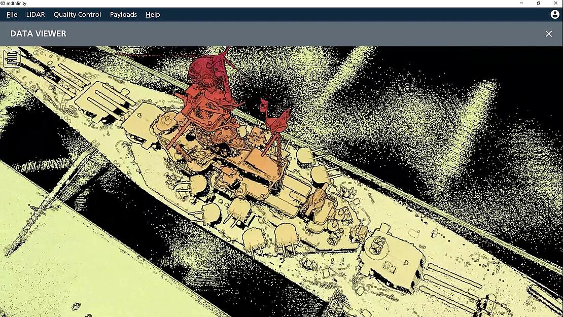
The data collection completed, it’s back to the office for post-processing. Jason Gibson, PLS for Thompson Engineering reviews the trajectory processing while working towards a final orthomosaic and then Robert Chrismon displays the digital twin of the USS Alabama in a LiDAR point cloud created in mdInfinity.
mdInfinity has now merged with LP360 Drone giving you more drone data processing power and deliverables. Now, users of Microdrones fully integrated systems can take advantage of the capabilities of LP360 Drone to transform raw flight data and generate colorized, georeferenced 3D LiDAR point clouds.
Once the data was fully processed, Adam Mccullough was excited to see the visualization. “To me the data speaks for itself. Just looking at the point cloud, you can see how dense and crisp it is around the buildings, the planes and all the cars in the parking lot.”
For more information on how you can start creating digital twins with drone LiDAR and LP360 Drone processing software, schedule a time to speak with one of our sales managers.