2018 INTERGEO Conference
The Microdrones Team was excited to take part in INTERGEO 2018 in Frankfurt last week. INTERGEO, held every year at different venues in Germany, is the world’s largest conference and trade fair for geodesy, geoinformation and land management.
Hosted by DVW- the German Society for Geodesy, Geoinformation and Land Management, INTERGEO proved again to be one of the largest industry events and trade show. With more than 19,000 visitors from over 100 countries, 640 exhibitors and a conference with more than 1,400 participants, this was a perfect venue to present Microdrones systems, workflow and capabilites.
Meet Microdrones
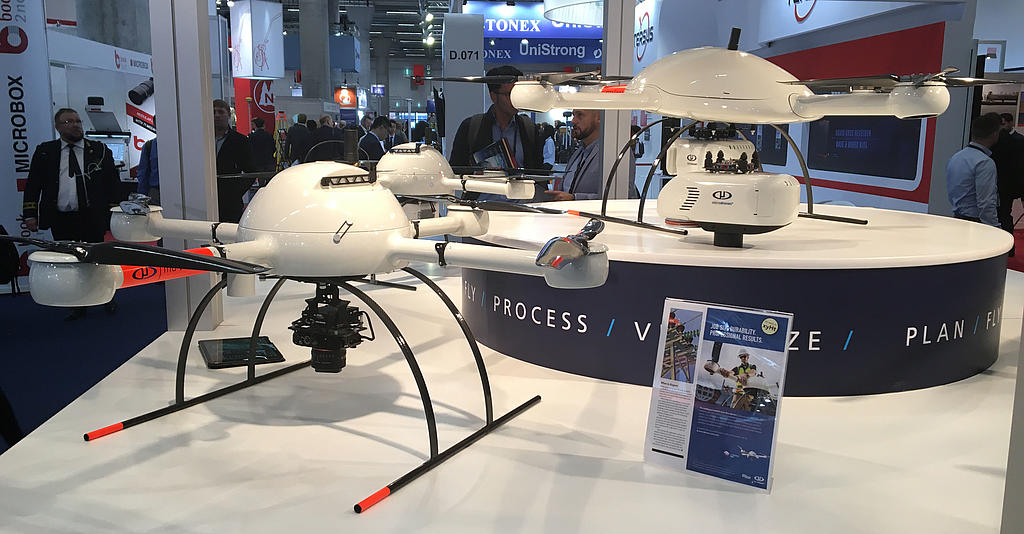
The Microdrones team left a great impression on INTERGEO attendees with presentations by Dr. Mohamed Mostafa, Director of mdSolutions, and product displays and information on the three new systems that were recently launched in October: mdLiDAR3000, mdMapper1000PPK and mdMapper1000+.
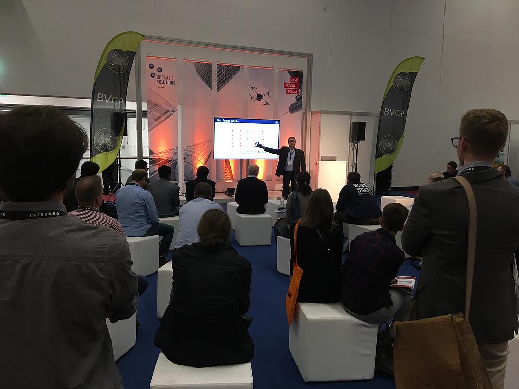
At INTERGEO, Dr. Mohamed Mostafa presented a helpful series of workshops to assist geomatics professionals in making drones a part of their work. He also showcased the three new systems launched by Microdrones.
The workshops were divided into three main breakout sessions:
- Tools not Toys: How to Achieve Professional Grade Surveying with Drones.
- Microdrones Product Overview and User Showcase
- Lunch & Learn: Top 10 Questions about Using Drones for Surveying and User Showcase
The following video details the launch of the three new systems: mdLiDAR3000, mdMapper1000PPK and mdMapper1000+.
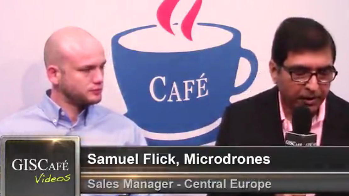
An Interview with Samuel Flick:
While attending INTERGEO, Samuel Flick, the Central Europe Sales Manager of Microdrones, participated in a Q&A with GISCafe. GISCafe is a portal offering GIS and geospatial professionals complete GIS product catalog listings, news, interviews, multimedia presentations, press releases, event postings, job placement and more.
Samuel answered questions about the new product launches, customer profiles, sales forecasts and industry trends. He noted that, “Our customers are very excited about these new products, because they present the whole solution, including customer support from the Microdrones Team. Furthermore, the new mdLiDAR3000 is one of the most advanced systems currently in the market providing some of the most high end data available.”
Watch Samuel’s interview here:
Next up on the Trade Show Tour: Trimble Dimensions
The tour continues next month at Trimble Dimensions 2018, happening November 5–7, 2018 at The Venetian in Las Vegas.
In addition to exhibition displays, Microdrones will host four very important workshop presentations for anyone who is interested in using UAV's for geomatics and construction work.
Click here to review the sessions and register! https://trimbledimensions.com/session-info/catalog/?search=Microdrones#/
Microdrones mdSolutions: Capabilities Overview of mdLiDAR, mdMapper and mdTector systems [GEO-1921]
SPEAKERS
Mohamed Mostafa, Microdrones
- Schedule
Wednesday, November 07, 04:00 PM - 05:00 PM | Lido 3001A
Users will walk away with an understanding of key benefits and features for Microdrones systems for UAV photogrammetry, UAV LiDAR, and UAV methane detection, as well as samples of deliverables produced using these systems.
Session Type: Classroom
Industry: Survey & Mapping
Session Topics: Survey - Photogrammetry & Remote Sensing, Survey - UAS & Mobile Mapping, Mapping & GIS, Survey - GNSS, Optical & 3D Scanning
Microdrones mdliDAR Product Line – from Field to Finish [GEO-1923]
SPEAKERS
Mohamed Mostafa, Microdrones
- Schedule
Tuesday, November 06, 11:30 AM - 12:30 PM | Lido 3101B
Users will be introduced to a fully integrated workflow for Microdrones LiDAR systems: plan, fly, process and visualize. From data collection, through delivery of a professional grade mapping deliverable, this training session will demonstrate established workflow for optimal results.
Session Type: Classroom
Industry: Survey & Mapping
Session Topics: Survey - Photogrammetry & Remote Sensing, Survey - UAS & Mobile Mapping, Mapping & GIS, Survey - GNSS, Optical & 3D Scanning
Unmanned Airborne LiDAR Systems: Theory and Practice [GEO-1603-P]
SPEAKERS
Mohamed Mostafa, Microdrones
- Schedule
Wednesday, November 07, 10:30 AM - 11:30 AM | Lido 3106
This presentation introduces Microdrones mdLiDAR3000 system that comprises a Microdrones md4-3000 drone, a Riegl miniVux-1UAV, a SONY Rx1RII, an Applanix APX20, and a fully integrated software workflow for flight planning, data acquisition, processing, and QC. System design, calibration, operation, mission planning, data acquisition, data processing, quality control, map production, point cloud colorization and accuracy assessment are addressed in detail. A few data sets collected in Canada and the USA are used to illustrate mdLiDAR3000 achievable accuracy.
Session Type: Classroom
Industry: Survey & Mapping
Session Topics: Survey - UAS & Mobile Mapping
Primary Audience: General – Everyone will love it
Professional Development Hours: PDH Session
Surveying and Mapping by Drones – What the Future May Bring? [GEO-1601-P]
SPEAKERS
Mohamed Mostafa, Microdrones
- Schedule
Tuesday, November 06, 04:00 PM - 05:00 PM | Lido 3006
Over the last few years, a number of sophisticated multi-sensor systems have been integrated onboard Unmanned Aerial platforms. This allows for producing a variety of mapping products for different mapping applications. This presentation focuses on presenting the current and future unmanned airborne multi-sensor systems including cameras, LiDAR, GNSS, Inertial and their integration aspects along with the fully integrated software workflow for data fusion and map production. The results of development and testing of fully integrated unmanned systems for professional grade mapping are addressed. There are a number of parameters that either individually or collectively affect the quality and accuracy of a final airborne mapping product. Also the use of different georeferencing systems including RTK, PPK, DG, or ISO directly influences the entire operation. This presentation will address assessment of the final mapping product accuracy through real-world projects and flight missions flown in Canada and the USA.
Session Type: Classroom
Industry: Survey & Mapping
Session Topics: Survey - Photogrammetry & Remote Sensing, Survey - UAS & Mobile Mapping
Primary Audience: General – Everyone will love it
Professional Development Hours: PDH Session
To meet up with the Microdrones Team or learn more about our new product launches, schedule some time to talk with our friendly, helpful sales team!