
KWS SAAT SE is the parent company of the KWS Group. It is a strategic leader and manages the propagation and distribution of sugarbeets and corn seed, along with other crops. It finances basic research and the breeding of a variety of crops in the portfolio of the KWS Group, and annually provides its subsidiaries with new varieties for propagation and distribution.
Recently the KWS Group featured a story and video on their website that shows how farmers are benefiting from drones in plant cultivation. The Microdrones mdMapper1000DG plays a significant role in acquiring the data and helping with the research.
Precision Farming
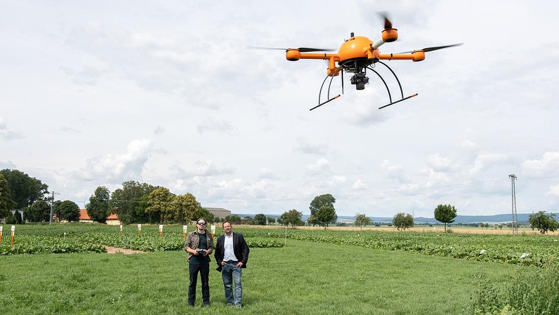
The four rotors from Marius Burkhardt’s bright orange aircraft begin to circulate, between the trial plots of KWS in Einbeck, Lower Saxony, creating a downdraft that gently rocks the crops. Then the drone rises in the air and quietly proceeds, following mathematically precise routes over the field in which maize plants, a few centimeters high and still wispy, are growing. Marius will be using the quadcopter to perform an analysis of the maize plants this morning.
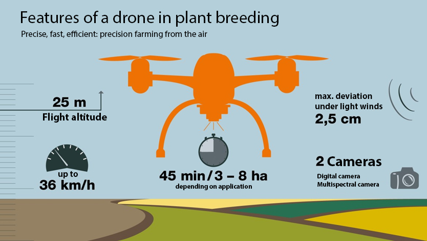
Below the aircraft hang several sensors taking pictures of the plants in the field to record their growth. With a fully charged battery the drone can fly for a half-hour, systematically recording between three and eight hectares, depending on the application and on the flight altitude, sensors, or flight plan. For today’s mission, a multispectral camera and a thermal imaging camera measure, in various wavelengths, the amount of light reflected and absorbed by the plants. Photos of the field are also captured during the duration of the flight.
Everything in sight
The cameras of the drone record every plant and allow inferences regarding growth and diseases. In the future, UAVs will be used more often in plant cultivation because they allow precise insight into the growth. The drones fly consistently at an altitude of 25 metres. The software can thus determine the exact GPS position of each plant.
Marius Burkhardt, monitors the operation, to ensure that the photos are taken consistently at a flight altitude of 25 metres. Only then can the software determine the precise GPS position of each plant and create a 3-D model of individual specimens. Through this combination of technical innovation and breeding experience, it is possible to breed new, disease-resistant plant varieties in less time than was previously required. Eventually, the seeds should produce plants with high yields even under the most difficult agricultural conditions.
“Farmers want to work with seeds that precisely meet their individual requirements,” says Dr. Christoph Bauer, who, as the manager in charge of the technology development for digital phenotyping at KWS, coordinates the drone flights and analysis of the data acquired. The new digital tools, developed internally at KWS, help the breeder in finding the plants that are best suited, among the hundreds of thousands of plants. “That helps our breeders locate the best plants,” says Bauer. “Drones and image analysis are becoming increasingly valuable tools.”
Precision farming: More precision in agriculture
The procedure behind it is as old as plant breeding itself. Using phenotyping, it can be determined whether new varieties can develop under the environmental conditions at a location. It can also help evaluate pest infestation. “For more than 160 years, specialists from KWS have worked in the field to assess plants,” says Bauer. “This is indispensable for developing new varieties.”
Every year, breeders sow new plants and then assess how they will develop in the field. They record sizes, colours, growth rates, the number and shape of the leaves, and other features. After much analysis and often very labor-intensive steps, breeders can select the varieties that are optimally adapted to the requirements of the farmer.
The aerial photos and data collected from their software significantly speed up this process and bring numerous advantages to the farmers, says technologist Bauer. The digital sensors can help detect fungal infestation, dry areas, and low chlorophyll content. Since measuring instruments and software do not tire, the data collected for the growth rate of plants, their leaf count and size are much more precise and available faster.
Specifically, notes Bauer, this highlights the imprecision of the human eye. He says, “If many people walk through a field and assess the development of the leaves, the result will usually be very similar. However, there will still be slightly different findings. It is precisely such differences that the technology, which is always objective, should prevent. It also displays its speed advantage. No person can assess such huge areas with this kind of unerring objectivity.”
Hundreds of drone photos, one complete recording
Plant breeders remain indispensable despite drones and software. For one thing, they must calibrate the measurements: “For us humans, it’s easy to distinguish between two beet or maize plants,” says Bauer. “Transferring this knowledge to a machine, however, takes a lot of work.”
For example, in the morning and in the evening, when the sun stays particularly low over the fields, its light is more reddish than at midday. When the sun rises very high in the sky at noon, the portion of blue light is higher. If, on dry days, there is still dust on the leaves in the morning, which is washed away by rainfall in the afternoon, the visual appearance changes anew within one day. Or when shadows fall differently in the morning and at midday. “We have to take all this into account and make corrections,” says Bauer. “Only then will we really be able to see the condition of the plants and the leaf diseases.”
And people are also indispensable in the analysis and use of the findings. After returning from the field, drone pilot Burkhardt stores the images in the analysis software. It assembles hundreds of photos into one complete recording. On screen, the virtual field displays fine lines in green, red, and blue. The team then discusses the data. What is the average leaf colour? How much space do the plants take up? What does this mean for further cultivation? Successes and challenges become clearly visible here.
Interdisciplinary research for phenotyping at KWS
There are many specialists in image analysis working in the interdisciplinary workgroup involved in drone recording at KWS. Christoph Bauer, a physicist, is in charge. His colleagues and their technologies are deployed worldwide at breeding stations and have already gathered many positive experiences: “We have combined our strengths from inputs from breeders, biologists, and engineers,” says Bauer. “So we have had joint success in analyzing the data.”
Being in the field remains critical for the plant breeder in his profession: They have to control the conditions of the measurements on site and draw conclusions for the breeding from personal observation. “We will never replace people,” says Christoph Bauer. “But the technology we develop in-house will support our peers in their breeding decisions.”
Nowadays, drones are flying over the fields of more and more farmers. Precision farming helps to save fawns and moles from the harvesting machines, facilitate early recognition of imminent drought, and map out molehills as impassable terrain in order to make conclusions about possible harvest shortfalls. The complex system of drones, sensors, software, image recognition, and servers that KWS uses for plant breeding, is being optimized on an ongoing basis. In fiscal year 2017/2018, the research budget was approximately EUR 190 million, or about 17 percent of the revenue.
Are you thinking about making drones a part of your work? Start by talking with our friendly, helpful experts!