The cover story for the most recent edition of Civil Engineering SURVEYOR featured an inside look at Project 14 of Down to Earth: Land, Sea, and Air.
Civil Engineering Surveyor, July/August 2023
By Danielle Kenneally
Ryan Tice, Owner, and Colt Ratliff, Professional Surveyor, Vice President and Survey Manager, Tice Engineering, and Bret Burghdurf, Marketing Director, Microdrones and GeoCue, spoke to Danielle Kenneally, Deputy Editor of Chartered Institution of Civil Engineering Surveyors (CICES) for a feature article in the July/August edition of Civil Engineering Surveyor.

While Microdrones began life offering drone surveying equipment and geospatial software to help civil engineering and surveying professionals, happenstance saw them realize the potential of a surveying reality series that showcase their equipment and software. It became known as ‘Down to Earth’ a series that features surveying projects such as the Great Pit in Sweden and the Ozark mountains in the US. Now into their fourteenth series and counting, they are in the birthplace of American blues, Mississippi, with Tice Engineering, an engineering company contracted by the Mississippi Department of Transport, to survey the bridges of the Pearl River. Its stars and producer, Microdrones’ Bret Burghdurf, and Tice Engineering’s Ryan Tice, and Colt Ratliff, spoke to the Civil Engineering Surveyor’s Danielle Kenneally, about showing how real surveyors collect data and turn it into real deliverables, despite challenging conditions, hidden dangers, and inclement weather, all while being filmed.
Can you give us an overview of the Down To Earth surveying reality show, from where it began and why it started to where it is now?
Bret: The reality series started about three years ago. The idea initially came about when we started creating videos that highlighted the ability of our products and their systems from planning and flying to processing and visualizing our drone surveying equipment. We were with a customer and had just made a great use case video when they started sharing some wild stories about surveying. These included close encounters with animals, such as alligators and snakes, and then another close encounter with a landowner who didn’t understand why they were on the property. As they shared these stories, we thought, wow, those are the types of scenarios that our customers can really identify with. We wanted to capture these real-life examples and create a reality show rather than just another marketing video. Our videos now actually show people in real situations, using our products to solve real problems. That’s its genesis. The series with Tice Engineering is now our fourteenth production.
How did Tice Engineering get involved and what was it like?
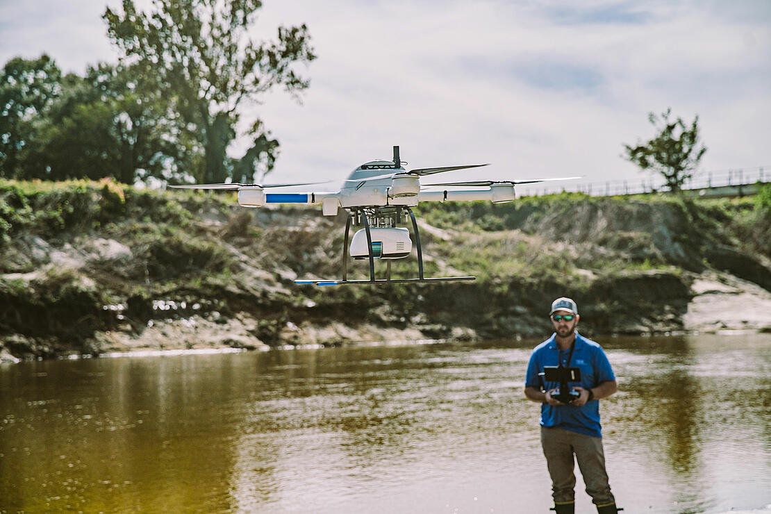
Ryan: We bought a mdLiDAR1000HR about two years ago for flying missions for surveying and collecting lidar data when Microdrones suggested filming one of our unique projects that we’re involved in – a survey of the Pearl River in Jackson, Mississippi. The project, which was for the Mississippi Department of Transportation, would see us survey for scour under the river’s bridges to determine whether there was any foundation failure due to erosion and to essentially monitor them.
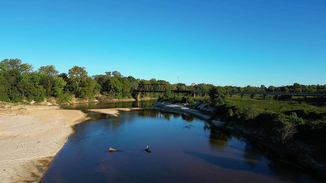
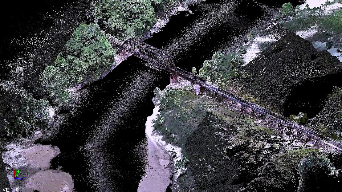
We were hired to do a bathymetric survey using lidar to produce a three-dimensional model from under the water, followed by a topographic survey of the railroad bridges. In this particular project, there were five bridge locations – one which was interstate, one a local highway, one a local road and then two railroad bridges. The Mississippi Department of Transportation did not have as-builts on the railroad bridges, so during modelling you can see the bridge piling acting like a weir. It meant that when the water hits the bridge pile, it would eddy the ground underneath, so surveying these bridges was a huge priority for public safety. We achieved this through a lidar drone from the air, a hydrographic scan by sea, and a terrestrial scan of the bridges by land and putting all three of these models together to create a three-dimensional model of the Pearl River. Bret: We’re always keeping our eyes out for customers who are using our systems for interesting projects. The first project that we developed for the Down to Earth series was on a mountain in the Ozarks, where there were engineers working to build a road down the side of the mountain. Each series is unique and the really interesting thing about this project with Tice Engineering is the incorporation of the three different pieces of technology.
Why was a survey needed for this ‘Down To Earth Land Sea and Air’ series’ project?
Ryan: The Pearl River cuts through the heart of Jackson, Mississippi and provides drinking water to hundreds of thousands of residents. However, the water source can also pose a threat to the local community when the levels flood. The river can fluctuate in elevation dramatically by 20-30ft. Plus, there’s a 33,000-acre reservoir for the city of Jackson, and we also get good rainfall, so when it is at that flood stage, an enormous amount of water needs to be released. We’ve seen flooding even 100 miles downriver. That’s why the Mississippi Department of Transport rely on us to survey 150 acres surrounding the Pearl River to examine flood zones and inspect bridge scour. To do this we scan over and under local infrastructure such as bridges and its foundations under the water.
Why are they important and what could happen if they weren’t monitored?
Ryan: Simply put, the bridge could collapse. We did a survey of a bridge on the Pearl River in a different location in Columbia, Mississippi on the Highway 98 in 2018, and when we came back and did another hydrographic survey in 2020, the scour had increased by 14ft. Urgent plans for a new bridge had to be put in place due to the dramatic increase.
Typically, in Mississippi, a bridge would have 15-20 piles in the ground probably 50-60ft to a hard surface. These are capped with concrete and then there’s the bridge support that is built on that base. This is where the 14ft scour hole, the piling underneath the bridge cap, was being exposed. It’s extremely uncommon, however, this was an old bridge built in the 1940s and one that needed replacing.
What equipment did you use for the project in this series and how did you use them to bring the data to the Mississippi Department of Transport?
Colt: A lot of planning went into the project before we could even begin, such as preparing the mdLiDAR1000HR drone missions using Google Earth aerial photography to understand the project site and map the drone flights. We also pre-planned the hydrographic missions using a multibeam echosounder on a drone Z-boat. However, we didn’t need too much pre-planning for the terrestrial scanner, a Trimble SX12, other than how we were going to access the site. The actual project itself took approximately two to three days with separate teams able to work on each element – two days for the drone work, another two days for the hydrographic scan, and then a day for the terrestrial scan.
Taking these three elements of a lidar drone from the air, the hydrographic scan by sea, and the terrestrial scan of the bridges by land, what were the benefits of doing it this way using the equipment?
Colt: Using all three elements meant we could create an all-encompassing three-dimensional model that the Mississippi Department of Transport was looking for.
Bret: Using the Microdrones lidar system also significantly reduced the amount of time spent in the field.
Colt: Yes, it would have taken several weeks if we were to cover the 150 acres of land by foot and even then, we would still not have had a fraction of the data that we were able to collect using the equipment and software we used. We were able to collect enough point data to create a three-dimensional model that is as dense as a photograph. Whereas in conventional terms, we may have only had one piece of data for every 100ft apart.
There was some concern about the tides, did this come into play at all and where there any other difficulties you came across when producing this for Down To Earth?
Colt: To be honest there wasn’t really, we would have liked to have had more water in the river to enable the boat to travel more freely and collect more data, but it wasn’t a major issue.
Bret: While the water wasn’t a really a problem, we did have to use some of the all-terrain vehicles to get us there and I may or may not have almost tripped over a branch on the side of an embankment. I wish I could say they always run smoothly, but we always run into a hiccup or two while we’re on site. It could be something as simple as the battery for the camera has run out or there is a drone firmware update. They can always be rectified though.
It’s a great series and something that hasn’t really been done before, especially as Microdrones have released more series with different projects. What do you hope viewers, including civil engineering surveyors, will take away from the episodes?
Bret: The episodes showcase how to use our equipment to solve challenges in the field. Tice Engineering’s work on the Pearl River was a huge project area. Normally, the work needed might take them anywhere from three to six weeks, but showcasing what equipment and software could be used to problem solve the site and deliver the clients’ needs created an exciting deliverable. We want to make sure that we’re telling the story that can help both our customers and their clients, and along the way that may help other civil engineering surveyors too.
Ryan: For us at Tice Engineering, we’re small fry in a big vat, so it’s a great exposure for us to be involved in the reality series and show our capabilities as a company.
What other civil engineering infrastructure projects can we look forward to seeing in future series of Down To Earth?
Bret: In our next series we’re in Alabama surveying a mining area so that they can add a conveyor belt in order to bring the material out of the mine, down to the barge and then down the river. All the projects we film are fascinating and we’re always looking for exciting projects.
We had a great time with Tice Engineering while on the shoot and who knows in the future, if they’ve got another interesting project, we’ll film with them again.
Ryan: It was great to be involved and we’d love to be able to explore something in the future.
For more information on adding drone LiDAR from Microdrones to your surveying projects, please schedule a time to meet with one of our helpful representatives.