LESS FIELD TIME, BETTER RESULTS
Surveying firm Fox & Associates invested in two Microdrones systems, deploying both photogrammetry and LiDAR payloads to produce accurate topographic surveys and volumetric calculations.
by Renee Knight
As seen in the August/September 2021 Issue of Inside Unmanned Systems

About three years ago, the team at Maryland-based surveying firm Fox & Associates decided it was time to invest in a drone. The goal was to create topographic surveys that the team would use for in-house work, reducing the time crews had to spend in the field while also producing a better deliverable for clients.
For Survey Technician/Crew Chief Richard Nagel, it was important to find an end-to-end solution. He wanted something that was easy to use, and that didn’t require him to make separate hardware, payload and software purchases. He also knew the team would have to spend time learning how to pull the data they needed out of the point clouds generated, so it was critical the system itself had a short learning curve.
The Microdrones mdMapper1000DG checked all those boxes. The system also provided IMU alignment for photogrammetry to speed up processing time- another feature that was important to Nagel.
“The industry was moving in this direction, and we wanted to get in front of it, not be the last ones to adopt the new technology,” Nagel said. “At the time, I looked at other companies and it seemed like the Microdrones system was the most comprehensive and professional. It’s just a well put together product.”
Earlier this year, the team decided to invest in a second Microdrones system: the mdLiDAR1000HR, which provides high resolution point clouds and increased coverage. While the mdMapper1000DG works great for bare earth and fields, the firm needed a solution that could penetrate through vegetation as well. The mdLiDAR1000HR gives them that. The two pilots, which includes Nagel, use the drones an average of four times a month, reducing time in the field and enhancing safety.
Richard Nagel, survey technician/crew chief, Fox & AssociatesAt the time, I looked at other companies and it seemed like the Microdrones system was the most comprehensive and professional. It’s just a well put together product.
The Applications
Fox & Associates creates a lot of topo surveys for residential subdivisions, Nagel said, a perfect job for drones. Before purchasing the Microdrones system, they sent crews of two to sites to set up control points and complete the work by foot. Surveying a 50-acre site usually took four or five days, with crews getting locations every 30 to 50 feet as well as identifying significant features such as hills, ditches, and banks. Now, they collect a much denser sampling with data from the entire site in four to six hours.
While most of the work can be done with the mdMapper1000DG, they rely on the mdLiDAR1000HR when they need a survey of a wooded area, Nagel said.
“A lot of the subdivision surveys we do are on raw land that’s been untouched for years, so they contain a lot of wood or overgrowth,” he said. “We’ve used the mdLiDAR1000HR on a few sites that were 90% wooded and produced topographic surveys that we used for base drawings or engineering design work.”
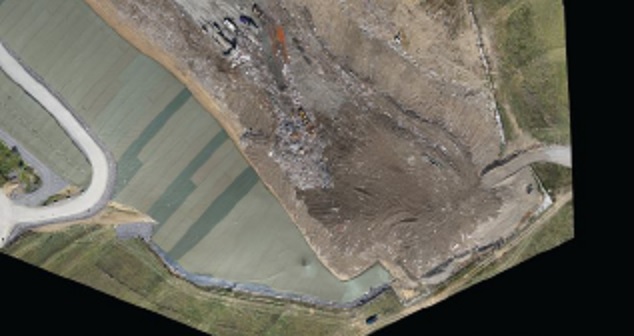
Fox & Associates also has a contract with Waste Management to perform quarterly volumetric surveys on two landfills, a task they once completed on foot, Nagel said. While trash is measured on the scales every day, Waste Management also wants to know volume so they can easily track landfill capacity.
Because the landfills are open bare earth, the team uses the mdMapper1000DG for those flights, Nagel said. They create a topo of the existing site, calculate the volume from the previous topo and give the client the volumetric measurement.
They also flew a landfill for Waste Management that’s near capacity, Nagel said, comparing the data to previous surveys to see how close the landfill is to final volume.
“Using the drone for these flights decreases field time and helps with the safety factor. Crews don’t have to be in dangerous areas of the site, especially with waste disposal,” Nagel said. “Typically, crews are working in what we call the active phase, when equipment is moving and pushing trash around, so using the drone helps us stay out of the way.”
The firm is also looking into the mdTector1000CH4 which would allow them to measure methane release at the landfills, Nagel said. If they decide to move forward, it will likely mean bringing on more drone pilots to help with the additional work these flights will entail.
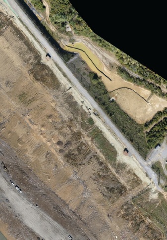
Other projects include generating a topo for an airport repaving and completing a boundary line survey along the Chesapeake Bay, Nagel said.
The Advantage of mdInfinity Software
While Fox & Associates uses its own software to manipulate drone-collected photogrammetry, they do rely on mdInfinity software for initial LiDAR processing. The software “certainly saves time,” Nagel said, and frees him up to focus on other tasks.
“It speeds up the process,” he said. “I only spend maybe half an hour or so on mdInfinity software before I have a good product. Then from there I put it into our software and create the final topo.”
Working with Microdrones
Since purchasing the first system in 2018, Nagel has worked closely with his Microdrones sales rep. He knows he can reach out to him whenever he has any questions, and that he’ll get back to him as quicky as possible. If he doesn’t have the answer, he’ll find somebody who does.
With the training and continued support Microdrones offers, integrating both systems was a smooth process. The biggest challenge, Nagel said, was learning how to work with the point clouds. Nobody in the company had much experience in that area, but after the first few projects the team became comfortable with that element as well. The fact Microdrones systems are so easy to use allowed them to focus on what’s most important: learning how to work with and getting the most out of the data collected.
“It seemed like all the other platforms out there would have required a lot of learning about how to use the system and put it all together,” Nagel said. “There wasn’t a good package deal. Microdrones was the only one we found that offered a good end-to-end solution.”
If you would like more information on adding integrated drone surveying equipment to your workflow, CLICK HERE to speak with one of our friendly representatives.