The Top Drone LiDAR and Photogrammetry Surveying Purchase Options
Everything you need to do drone surveying the right way, with convenient packages and payment options.
Geospatial Productivity Made Simple and Affordable.
Microdrones is making it easy for professionals to get started with everything needed to use drones for complex surveying work.
EVERTHING YOU NEED FROM MISSION PREP TO DRONE SURVEY EQUIPMENT AND POST PROCESSING- ALL FROM ONE COMPANY.
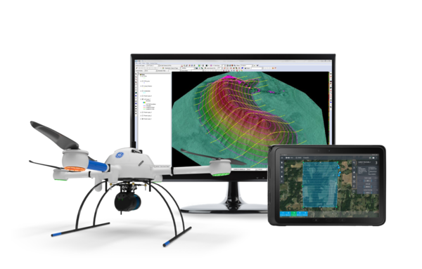
Microdrones is providing a full drone survey equipment and software package, with powerful mdCockpit and LP360 Drone software.
HARDWARE, SOFTWARE & MAINTENANCE
Complete mapping solution offered by Microdrones composed of Survey Equipment and Data Processing modules fully adapted to that Survey Equipment.
HARDWARE and SOFTWARE
The necessary equipment to gather Data using a UAV. It includes the drone, the payload and Microdrones proprietary mdCockpit mission planning and control software. Data collected with the survey equipment can be processed exclusively within LP360 Drone.
Any available Software module which can process and facilitate the analysis of data through LP360 Drone Software platform.
BUSINESS MODELS
Unlimited access to basic software (trajectory processing and geocoding) Owner pays annual software and firmware maintenance fee. Ask for details.
(Available for mdLiDAR1000UHR Lite only)
40 data collection minutes included, with additional minutes available on an as needed basis.
Maintenance
Yearly UAV Payload & Software maintenance for your drone survey equipment.