
OUT IN FRONT
AGE Engineering Services invested in the mdLiDAR3000DL from Microdrones to offer clients the latest technology and to quickly deliver the robust data they need.
by Renee Knight
As seen in the June/July 2020 Inside Unmanned Systems
When the team at Kentucky based AGE Engineering Services decided to invest in a drone in 2014, it just seemed like the next logical step. The company strives to stay on the leading edge of technology, and at the time was successfully processing and using data from the newest ground-based scanners. That was great, but they wanted to see how unmanned aircraft systems (UAS) could elevate their business even further.
They started out with a fixed-wing UAS they could mount a camera to, said Lucas Harris, a professional land surveyor with AGE, and from there invested in several quadcopters. After a few years of benefiting from what photogrammetry can provide, it was time to take advantage of the latest cutting-edge drone payload: LiDAR. Harris did the research, traveling to demos and trying out various drones, and found the Microdrones mdLiDAR3000DL was the best option. The system combines the md4-3000 drone with a Riegl miniVUX-1DL and a SONY RX1R II camera.
“Microdrones offers the most complete solution you can buy,” Harris said. “The competitors might have a good payload, but you have to pair it with a drone on your own, or maybe you have to mission plan in some other program. As soon as we saw the Microdrones solution and how it worked, we could tell their engineers had designed an actual system. There was no piecing together a payload with an aircraft. Everything was already there.”
Lucas Harris, Land Surveyor, AGEWe just did a project that was roughly half a mile that would have taken a week with guys on the ground. The data we collected with the drone is 10 times better and took about two hours to capture.
Why LiDAR
Photogrammetry works well when surveying dirt construction sites or road surfaces, Harris said, but the cameras just can’t cut through sites with trees or high grass—making it difficult to get good surface models. LiDAR, on the other hand, penetrates through foliage. With the Microdrones solution, the team can quickly capture ultra-dense LiDAR data in the field, and then turn it into a 3D colorized point cloud for their clients.
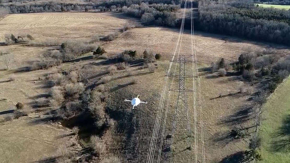
AGE does a lot of work for power companies, Harris said, which is another reason they needed a robust, durable system equipped with LiDAR.
“You can’t get wire information with photogrammetry,” Harris said. “The biggest thing was that we needed the ability to fly powerlines and corridors and capture data on the wires. We’ve done ground-based scanning to collect that kind of data for years. We just did a project that was roughly half a mile that would have taken a week with guys on the ground. The data we collected with the drone is 10 times better and took about two hours to capture.”
Other Projects
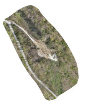
Since purchasing the mdLiDAR3000DL last August, Harris has flown about 20 different jobs. The biggest so far involved a 300-acre topo near a lake. A new bourbon distillery was planned for the site, so while the actual ground surface was the main data everyone was after, the client also wanted to ensure the tasting room sat at a point on the hill that offered a nice view of the lake. That meant AGE needed to provide LiDAR data on the surrounding trees and homes and other objects that couldn’t be moved.
With a crew of two to four surveyors going out with GPS every day, it would have taken a month to topo that site, Harris said. They collected the data in two days using the drone.
Another interesting project involved a small “slide” on the side of a mountain where transmission lines ran through, Harris said. The ground at the base of the transmission structures began to fail and the power company needed to map the slide, wires and structure. Harris was able to fly the corridor in a day without ever putting any workers near the slide.
“It would have taken three or four days to maybe a week to cut lines through the woods and traverse with a total station with a couple guys running rod,” he said. “The guy running the total station would have had to take shots maybe every 20 feet or so to build a surface and shoot all the attachment points on the transmission lines. Certainly, the big advantage is we did that job in one day and came home. And we got 100 times more data and it took maybe a fifth of the time to capture it.”
Harris also has flown sites planned for new substations, using the data collected to determine grading and new tap points on the transmission lines, he said. He’s completed coal ash mound volume calculations for power plants, surveyed new sub-division developments, and taken on jobs for local school boards planning to build new schools. No matter what type of project the AGE team is working on, Harris said clients are happy with the dense data they’re able to collect in such a short amount of time.
Staying Ahead of the Curve
Working with Microdrones has been a positive experience, Harris said, with the company providing the training and support needed for AGE to successfully implement the system into their workflow. Since purchasing the mdLiDAR3000DL, Harris has also looked into investing in Microdrones photogrammetry payloads and the mdTector1000CH4 aaS, which is used for methane detection. While AGE hasn’t purchased either just yet, Harris knows they’ll have guidance and support from the knowledgeable Microdrones team once they do.
Meanwhile, the system they do have has helped them improve efficiencies and quickly provide various types of clients with the rich data they need.
“It enables us to overcome the time factor. We can quickly build a survey in a really large area with rough terrain without putting guys out in the field for a few weeks,” Harris said. “And we’re able to stay on the front edge. If we don’t use the newest technology for our clients, somebody is going to come along who will and then in five years they’re going to have our jobs. We certainly don’t want that.”
If you or your company is interested in adding Drone LiDAR into your workflow, CLICK HERE to speak with a friendly representative from Microdrones.