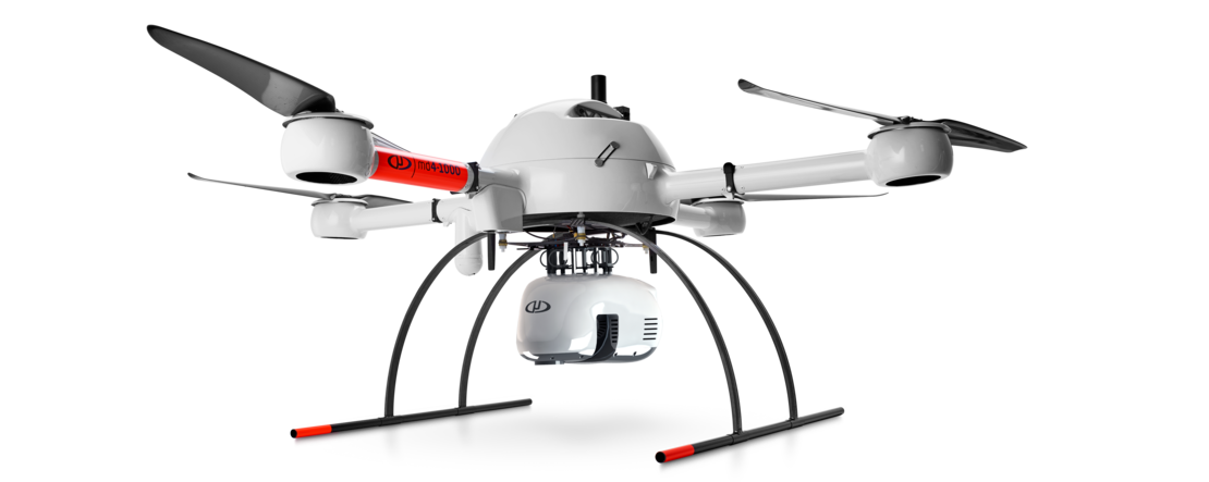
High Resolution Drone Lidar
The mdLiDAR1000HR aaS is the next generation of industry leading drone Lidar survey equipment offered by Microdrones. The mdLiDAR1000HR aaS uses the lifting power, resilience, and efficiency of the Microdrones aircraft platform to carry a perfectly integrated Velodyne VLP-16 PUCK LiDAR sensor for increased coverage and the ability to deliver high-resolution point clouds.
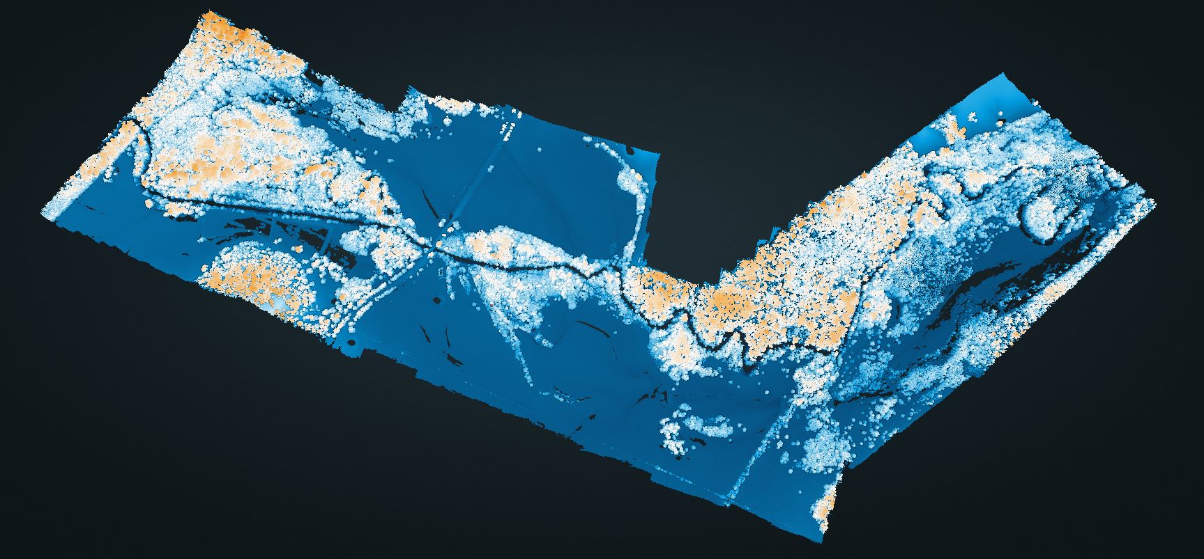
To demonstrate the high-resolution point clouds that can be created from data collected with the mdLiDAR1000HR aaS, Ross Kenney, UAS Sales and Support Lead for Navigation Electronics used the new LiDAR system in an extensive 1800 acre survey over the course of 3 days and 28 flights. Click Here or on the image below to view the point cloud created from that survey which was also used to measure sediment deposit around a creek on 2 private tracts of land.

Sediment Issues
The area of interest for this survey was downstream of a construction site. While the project was being built, materials on site were stockpiled. Unfortunately, heavy rains washed these materials downstream of the construction site, to be deposited on private property, causing a disruption to the landowner’s use. In one case a sod farmer had less area to cultivate and in the other a cattle rancher had less grass available for grazing.
Therefore, a survey was required to assess and fully quantify the total amount of sediment deposited. Due to the size of the area, elevation changes, and unstable footing, a traditional survey would be very costly and time consuming. Additionally, to fully analyze how much sediment was in place would have required excess GPS shots using conventional methods.
Kenney and the team at Navigation Electronics decided this was a textbook case to use the new mdLiDAR1000HR aaS and see if there was enough resolution to quantify sediment deposits. “We had just taken possession of the new HR system and we also were very curious to see how it would function in this type of an environment,” said Kenney. “What we came to find is that it really soared. It just was the perfect tool for the job.”
The Workflow
Each project was conducted using the Microdrones workflow of Plan, Fly, Process and Visualize. Mission and flight preparation details, as well as the flight parameters and data acquisition will be reviewed for each flight.
Plan and Fly: 1800 acres in 3 days
There were 2 separate properties to be surveyed for this project with one area 1,200 acres and the other 600 acres. The entire 1,800 acres was flown over the course of three days and 28 flights. “We covered about 60 acres per flight and each flight was about 25 to 30 minutes,” explained Kenney. “I think the longest flight duration of all 28 flights was right at 29 minutes and 16 seconds.”
Across all 28 flights, the mdLidar1000HR aaS flew at an altitude of 50 meters, with 50% overlap at a speed of 5 meters per second leading to a point density of over 280 points per square meter.
Process and Visualize
The point cloud was created and processed through the mdInfinity software suite using the following data processing modules: Trajectory Processing, Georeferencing, and Precision Enhancement (+ noise reduction) to insure an accurate and precise point cloud. Using the mdInfinity ground classification routine, vegetation can be removed and the bare earth data can be further processed to develop digital terrain models.
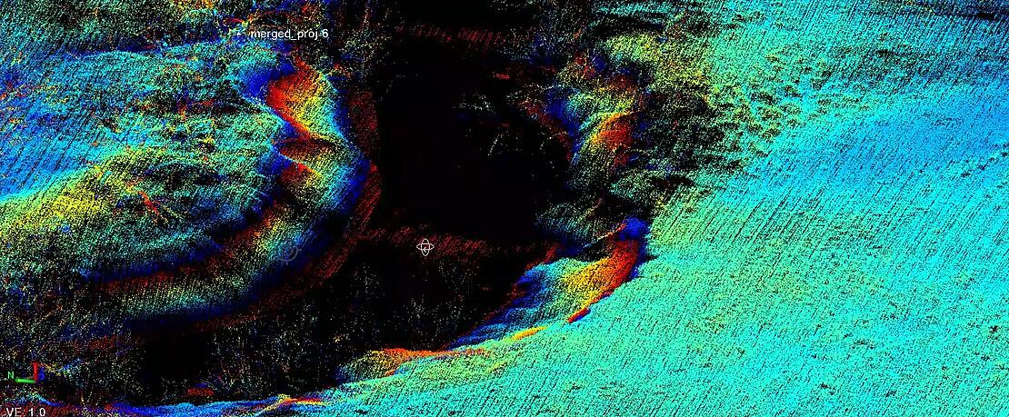
The Creek Data
After finishing the plan and fly portion of the 1800 acres, Kenney also processed and visualized the data to create a full surface model. The mdLiDAR1000HR aaS was able to provide the information and data needed to detect the sediment deposits.
“Look at how well-defined the banks of the creek are and you can see this blue area right here, you see the difference in elevation,” Kenney pointed out. “This is all your sediment, right here.”
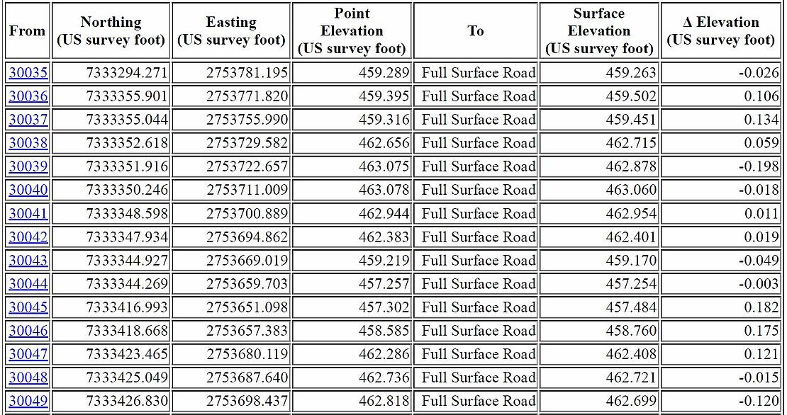
Accuracy Checks
To get an accuracy assessment of the LiDAR surface compared to the GNSS points that were taken with the rover on site, Kenney compared the GNSS location data to the point cloud, which yielded impressive results.
“Of those 70 check shots, when you average all of these points out, you'll find that the accuracy overall was on average between 0.05 and 0.10 of foot vertically,” explained Kenney. “So, we're talking about a centimeter and a half to three centimeter vertical accuracy on this particular area. That is phenomenal to accomplish that with a system of this cost.”
Increased Productivity
Kenney also noted the new mdLiDAR1000HR offers an increased range as well as field of view. “At 70 meters altitude the mdLiDAR1000HR can cover a 100 meter wide swath on the ground,” he said. “So that's a football field in length that you can cover with the width of your scan. That's a game changer in terms of the productivity because it’s about four times of the mdLiDAR1000 based on the results that we were seeing on this project here in particular.”
The Main Advantages off the mLiDAR1000HR
The mdLiDAR1000HR aaS provides the ability to collect high density data based on the 16 channels. This enables a faster and more efficient flight when compared to mono-layer LiDAR. This drone LiDAR system also provides a higher level of detail and better canopy penetration thanks to the large horizontal and vertical LiDAR field of view. Due to this classification routines can be performed with better precision than with point clouds with a lower density.
Data processing modules applied in mdInfinity create a unique layer per layer calibration process to enhance point cloud precision along with the ability to filter LiDAR data for point cloud quality enhancement resulting in best-in-class point cloud accuracy and precision.
For more information on putting drone LiDAR to work for you, CLICK HERE to speak with one of our friendly representatives.