Microdrones helps take marathon surveying project to finish line
A marathon of an assignment presented a big test for Aerisurvey.
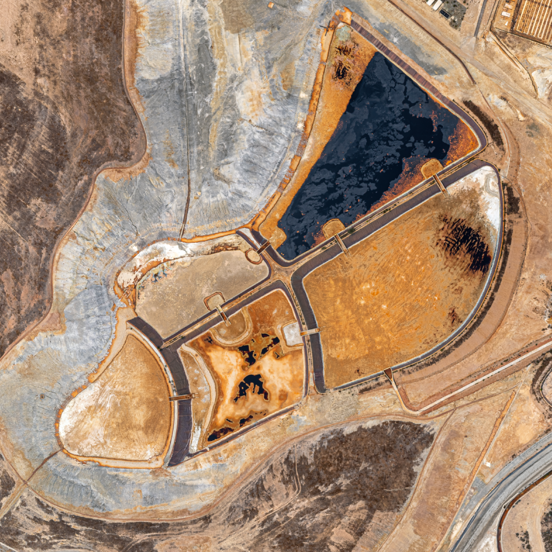
A high-profile client asked the Portugal-based firm to survey 20 quarries in 60 days, during wintertime, no less. Producing accurate results on such an accelerated timeline had the potential of enhancing Aerisurvey’s already solid reputation.
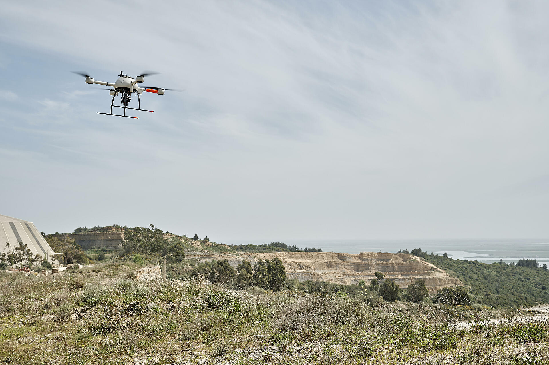
It took hundreds of drone flights and about 7,500 miles on the road driving from location to location, but Aerisurvey crossed the finished line. Nuno Santos, the company’s do-it-all founder and CEO, relied on the Microdrones mdMapper1000DG to finish the daunting series of photogrammetry surveys.
Santos served as pilot, operator and data specialist on the important project. “We proved that (the customer) can count on us and can know that they have a service provider using this kind of technology that can give this kind of quality data,” Santos said.

“The mdMapper1000DG ticks all the boxes.”
Santos started Aerisurvey in 2017, but he speaks from years of experience overall as a geologist who once employed traditional methods to survey quarries. He recalls one assignment in Africa in 2013 over tough terrain that required 14 different total station bases and took three weeks to finish.
One day, a former colleague showed him a demo of photogrammetry survey with a drone that used a small sensor, with the traditional computer-aided design (CAD) drawing superimposed over a photo map.
Santos started thinking of the possibilities. He had been playing with RC models since he was a child. Santos also was interested in photography.
What if he could combine his hobbies into a valuable tool for work?
“They weren’t great results, but he proved a point with the demo with what they can do on the mining side,” he recalled about the demo.
Nuno Santos, CEO AerisurveyYou don’t replace traditional methods. You just compliment. We believe so much in this data. We proved that with our technology and our data, and also the overlap, that everything we do, we prove it can be even more reliable than what they were doing in the last decade, at least.
Standing out
And so, Santos started incorporating drone photogrammetry into his workflow. While it saved valuable time, he wasn’t completely satisfied with the quality of the data.
In 2015, most of the surveyors and engineers relying on photogrammetry had no background in photography. “And it’s fair. It’s normal, in fact,” he said.
But Santos saw an opportunity to stand out. In launching Aerisurvey two years later, Santos said his goal was to create a final product that was “much higher in quality than anything else that I saw in the market, at least here in Portugal.”
At the time, others offering drone surveying services didn’t primarily rely on the results from the drone, but on collecting ground control points, or GCPs. Surveyors and other geospatial professionals often install many ground control points for large projects to ensure accuracy. But no ground control points are necessary with a direct georeferencing UAV mapping solution.
He switched to the mdMapper1000 in 2019 and now does 90% of the work with the workhorse system. He said the results are so reliable that a surveyor who primarily used ground control points recently hired Aerisurvey to compliment his work with drone photogrammetry.
“You don’t replace” traditional methods, Santos said. “You just compliment.”
“We believe so much in this data,” he added. “We proved that with our technology and our data, and also the overlap, that everything we do, we prove it can be even more reliable than what they were doing in the last decade, at least.”
Consider the assignment of 20 surveys in 60 days from Portugal’s Ministry of Economy as a case study. Santos initially had his doubts, especially since the work would have to be done in December and January that year. Weather conditions and extensive travel added potential hurdles.
Throw in another assignment for a separate client on a similar deadline at the same time, and Aerisurvey actually was working on 21 surveys in two months.
High Quality Results
At one point, Santos remembers nibbling on Christmas candies and opening presents while cleaning point clouds. Working on an accelerated timeline offered little time for rest – or even to check if the data was correct.
“You just collected the data and went back to the office, transferred it, then started driving again,” Santos said. “We couldn’t check, so every time we did a survey in the field, we made backup copies.”
The government project had other components, too, with other firms performing different tasks, so it was imperative that Aerisurvey stay on schedule. The long hours paid off: Aerisurvey’s on-time deliverables included orthophotography, contour maps, ground points showing different densities, individual records for each GCP, point cloud, ready-to-print maps, a full 3D model and aerial videos.
Providing the same amount and quality of data through traditional means would have cost much more money for any client. The government ministry was pleased, he said.
“They had never seen such quality data especially in such a short amount of time.”
The assignments kept coming with another quarry survey a month later. Two months later, they surveyed three more quarries.
“This was only possible with the Microdrones system. We know this is a system that never failed us before,” Santos said. “Only with this kind of system were we able to say ‘Yes, we can do that.’”
Aerisurvey’s mdMapper1000DG is equipped with the Sony RX1R II camera with 42.4 megapixels, paired with a custom, light-weight, vibration-free, nadir mount. Santos is impressed especially with Microdrones’ Direct Georeferencing feature, which is a highly accurate and efficient way to connect aerial images to their position on the ground by measuring true 3D coordinates and orientation angles of any sensor. This reduces the amount of time needed to collect and post-process data, and eliminates the need for ground control points.
“Our goal is to change the mentalities of our clients, and of friends of the clients, and prove that with this technology, you can have better results than what you were doing in the last decade or so,” he said.
“To say that with such confidence, you need to be sure about the quality of data you are giving.”
To learn how you can create high quality results using the integrated systems from Microdrones, CLICK HERE to speak with one of our professional representatives.