
Mistakes Made by Drone Early Adopters – And How to Avoid Them
with Hanno Truter
Adopting drones in your organization can bring a variety of benefits – but it’s also important to avoid common pitfalls.
Drones are here to stay, with UAVs and other solutions making surveying, imaging, and a variety of other tasks much simpler. This can bring a wide range of benefits to your organization – provided you can avoid common pitfalls drone early adopters face.
On this episode of Propelling from Microdrones, host Shelby Skrhak was joined by Hanno Truter, the Microdrones Sales Manager for Africa, to highlight some of those slip-ups and how you can avoid them.
The duo discussed evaluating the best fit for your unique needs, ensuring the right infrastructure and teams are in place before adopting drone use, and the mistakes Truter commonly sees early adopters make.
Hanno also identifies five key considerations for companies looking to bring drones into the equation – engineering quality, data accuracy, airframe design, cost, and flight time capability. Learn more about avoiding mistakes made by early drone adopters in the podcast or summary below.

Picking the Right UAV System
“Regardless of your business, there’s a well-worn saying from Benjamin Franklin,” says Hanno Truter, Microdrones sales manager for Africa. “‘The bitterness of poor quality remains long after the sweetness of low price is forgotten.’”
According to Truter, Franklin’s warning, when it comes to choosing which drone to purchase for your surveying needs, couldn’t be more on the mark. Too many first-time drone adopters are seduced by the lower prices of a low-end drone, only to realize later it can’t accomplish all they want, and they wind up paying double.
Deciding which drone to purchase based solely on cost is understandable, but a big mistake, according to Truter. Those considering a drone for their surveying projects should first look at what they are trying to achieve. Which solutions will get them or their customers the best results for which they are looking.
Additionally, purchasers should look for a solution that grows with them.
“It really isn't worth trying to take a shortcut when doing this. You want a drone that you can use for a very long time,” Truter said. “You don't want to buy a drone now, and two months down the line when you need to do a different type of survey, you're stuck with a drone you can't use and you need to buy something else.”
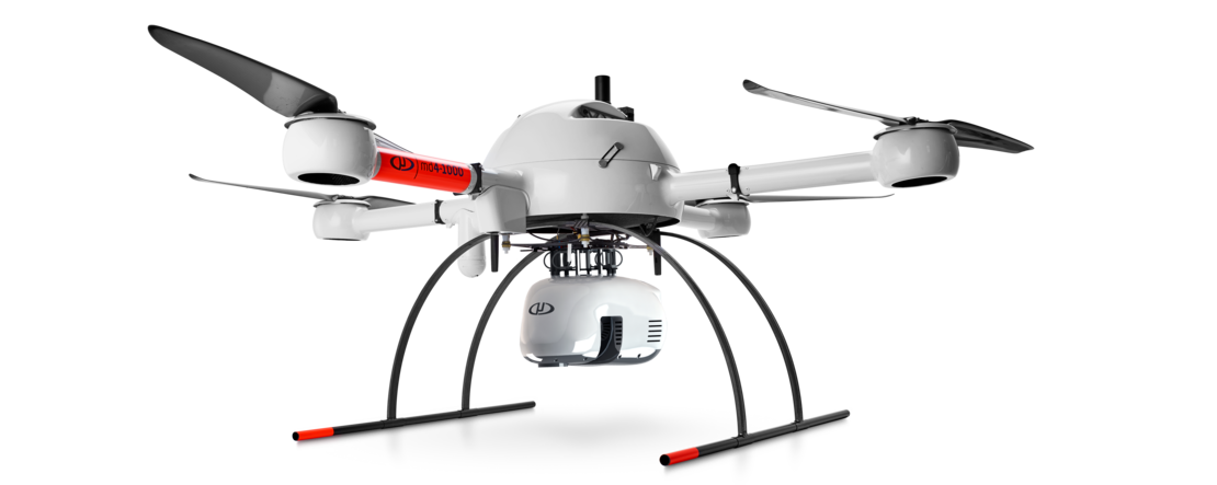
Microdrones UAV systems are fully integrated, Truter said. You can buy one drone with an RGB camera fitted to it, but two or three months down the line you may need to do a different type of survey, like a LIDAR survey. With the Microdrones solution, you can buy the LIDAR payload separately and change the RGB camera out quickly and painlessly, he said. That flexibility will save you money in the long run.
Had Franklin – one of the wisest of the United States’ founding fathers – envisioned the way drone technology would take hold of the 21st century surveying industry, perhaps he also would have advised potential drone buyers to pay heed to some additional factors beyond cost.
Hanno Truter, Microdrones Sales Manager for AfricaA drone mapping package is a serious business tool, and it's an extension of your existing toolbox and it should be purposely built for work
Key Considerations For Drone Selection
Truter says there are four additional, key considerations for companies looking to bring drones into the equation – engineering quality, data accuracy, airframe design and flight time capability.
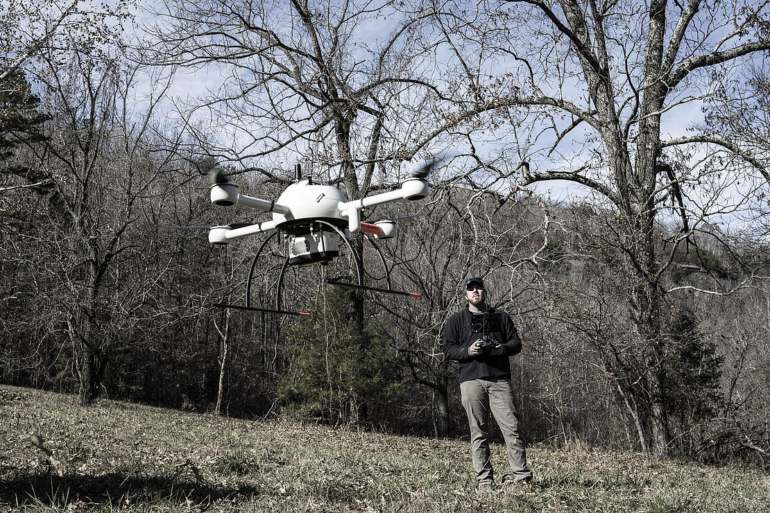
Perhaps no factor is worth more consideration than flight time. Surveying sites are big and UAV mapping, inspection and aerial photography take time. Temperature, wind, payload and other issues also affect flight time.
According to Truter, you want to look for a manufacturer that will demonstrate its solution’s actual flight time. Many manufacturers will cite flight times that differ vastly from the actual results in the field. In some cases the flight times cited don’t take into account the payload or even weather conditions.
“When you fly using a heavier payload, say for instance a LIDAR sensor, your flight time is going to be much shorter because the motors need to work harder to keep the drone in the air,” Truter said. “And obviously if you've got a crosswind or a headwind, that's also going to influence your flight time.”
And because all drones eventually need to land and recharge, you want a system that keeps track of where it left off, Truter said.
While long-term cost and flight time are essential factors when considering your drone purchase, engineering quality and data accuracy are not to be overlooked. A “starter drone” or one without professional engineering standards may not be able handle temperature fluctuations, windy conditions, sand clouds, debris and many other environmental challenges. And you will want a drone solution with a track record of successful mapping, one designed and integrated for professional applications, Truter said.
“A drone mapping package is a serious business tool, and it's an extension of your existing toolbox and it should be purposely built for work,” he said.
Last, but not least, Truter considers the drone’s airframe design crucial. The Microdrones system uses a four-rotor design for maximum stability, and the big, low RPM motors provide plenty of power while making efficient use of battery power. And that helps the drone stay in the air longer to complete big survey projects.
Requirements for flying a drone vary from country to country, Truter said. Most often, you’ll need to obtain a remote pilot’s license and there are drone flight school’s that can provide assistance. To fly a drone commercially (charge for your services), you’ll also need a remote operator’s certificate. Some countries, Truter said, require the operator to have a letter of approval from their local civil aviation authority, a drone safety approval and a registration number or marking on the airframe.
Guided by the five essential factors – engineering quality, data accuracy, airframe design, cost and flight time – a drone purchase, for Truter, comes down to one question. What are you trying to achieve?
“Long before Microdrones even sells the drone to the customer, our team has worked very closely with the end user to understand what they are trying to collect and how they're going to apply it,” Truter said. “And according to that, you can make an informative decision on what solution will be the best fit for your customer.”
Microdrones as a Service
Getting started can be easy and affordable with Microdrones as a Service, which at its core gives the customer more choices over how to acquire and configure both the hardware and software. Here are the basics:
- Choose the integrated system for your mapping and drone projects.
- Select how you prefer to pay for that surveying equipment. There are two options:
- Buy it. You are responsible for maintenance and any upgrades.
- Rent it through a hardware as a service agreement. Microdrones handles all the maintenance and upgrades.
- Pick your data processing plan. You may want to pay per project or go with an unlimited option if you’re a heavy user.
With Microdrones as a Service you can actually start using drone surveying equipment at a much more affordable rate, either through renting or purchasing the hardware and paying for the software as you go.
If you'd like to add drone surveying equipment from Microdrones to your tool box, CLICK HERE to speak with one of our friendly representatives.