
Georeferencing
mdInfinity is a unique data processing software solution that is packaged with either the purchase or rental of drone survey equipment from Microdrones to help you quickly and efficiently process geospatial data.
Microdrones has created a series of videos that take a closer look at the mdInfinity data processing modules to explore why they are important and what benefits they provide. In this video, we review how to do Georeferencing of drone survey data. Watch in the player below or read the following summary.
How Does Georeferencing Work?
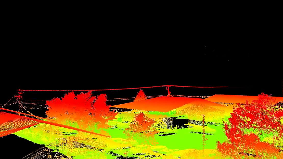
Georeferencing is the process of anchoring geographic coordinates to every point of your point cloud. This data module transforms the raw scan data from the LiDAR (range and bearing angles), the GNSS, and IMU (orientation and positioning) to provide a georeferenced 3D point cloud and associated data without any geodetic distortion, or in a local mapping frame specified by the user.
The Georeferencing module is applied after the Lidar data has been processed in the Trajectory Processing module.

Getting Started with Georeferencing
mdInfinity allows you to process your data whether it’s on the cloud on the desktop version and improves your workflow with easy, repeatable results. The software is adapted to work seamlessly with Microdrones surveying equipment. Upon logging in to mdInfinity choose the Georeferencing module in the project dashboard and follow the steps to process your files.
1. Input
To start, select the Georeferencing tab in mdInfinty and begin with the first step: Input. You’ll need the SBET file created from the trajectory processing module, to drag and drop into the Trajectory file window. You will also drag and drop the raw Lidar data into the Lidar raw data field.
2. Output
The next tab creates the Output files. Start by entering the field of view that was flown and then select the preferred file type. The next step is to choose the Output Coordinate System with the horizontal and vertical datum.
3. Process
On the final tab of Georeferencing, you’ll be able to review a summary of all of the information you’ve input. Upon review, click the Process button to create your georeferenced files and view them in the appropriate file reader.
The Benefits of Georeferencing
One of the benefits provided by Microdrones is the streamlined workflow all through one suite of software in mdInfinity. The Georeferencing Data Processing Module in mdInfnity allows the user to produce a highly accurate georeferenced point cloud that includes all associated data to the point cloud.
Therefore, the point cloud is not only a collection of the geospatial data, it also contains the uncertainty levels of each point and a copy of the raw data in such a way that denoising and calibration tools can be used to further enhance the data. Microdrones is also able to adapt Georeferencing to any Lidar system.
In summary, Georeferencing transforms the raw Lidar data, providing range and bearing angles, as well as IMU data, altitude and positioning to a point cloud with all of the associated data. With the specifications of the raw data, Microdrones produces a georeferenced point cloud in geographic coordinates without any geodetic distortion, or in a local mapping frame specified by the user.
To learn more about using the Georeferencing Data Module in mdInfinity, CLICK HERE to speak with a representative from Microdrones.