Drones for Surveying /

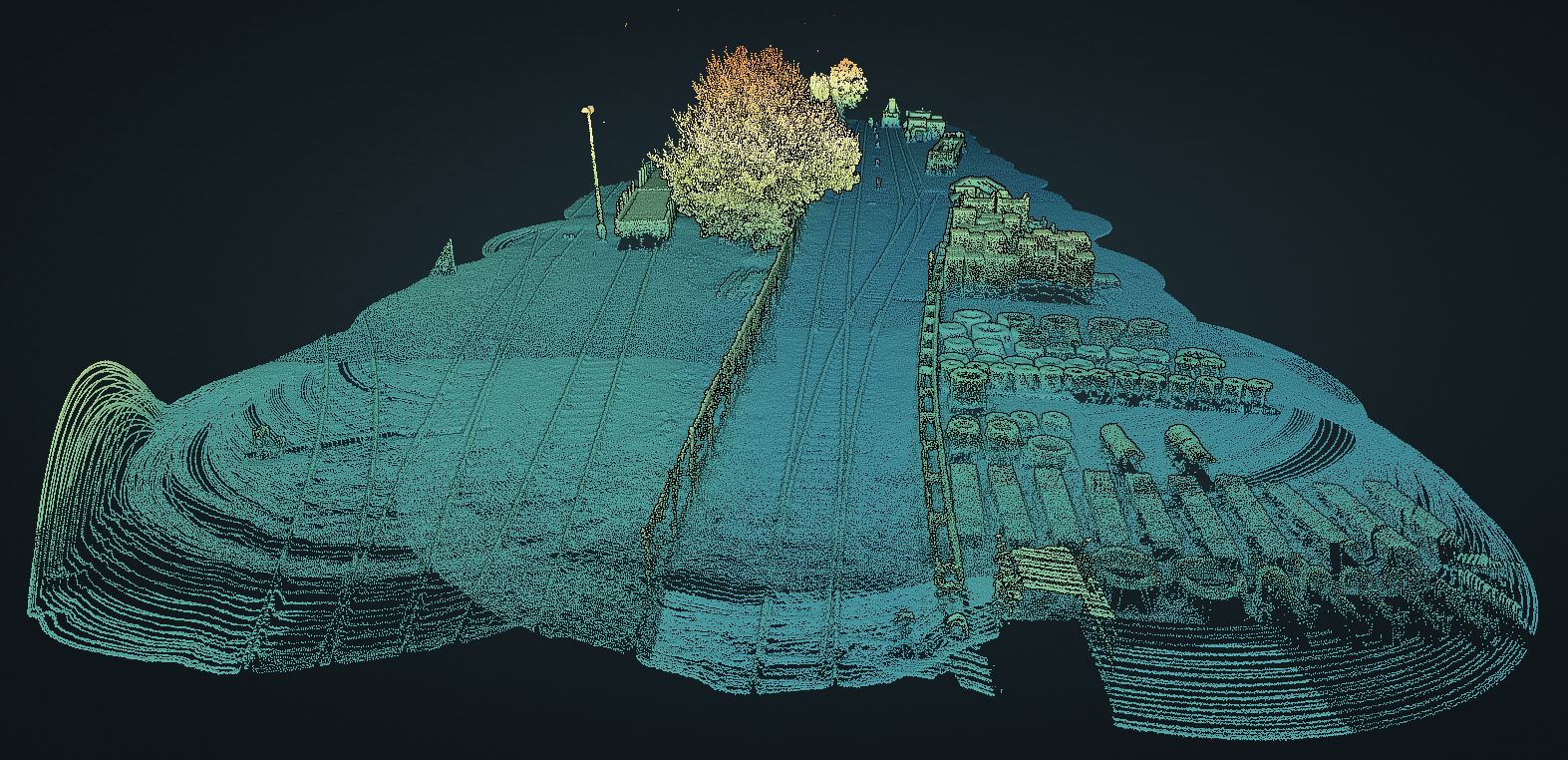
How to Extract Rail Tracks with LP360 Drone

In this workflow video, Jaume Cazorla, the LP360 Customer Success Manager for Europe, will demonstrate the workflow to extract rail tracks in LP360 without the need to employ other software...
Drohnen-LiDAR Datensets /

Ansicht einer Stromleitungs-Punktwolke aus dem Drohnen-Lidar mit größerer Reichweite mdLiDAR1000LR

Um die Fähigkeit zu demonstrieren, ein größeres Gebiet abzudecken und hochauflösende Punktwolken zu liefern, die aus den mit dem mdLiDAR1000LR gesammelten Daten erstellt werden können, hat Microdrones...
Down To Earth /

Drohnen-LiDAR-Punktwolke für eine Bestandsaufnahme

Sehen Sie sich eine Punktwolke an, die von Spatial Data Consultants in der Reality-Serie Down to Earth, Spatial Experts für die Erstellung eines As-Built Survey verwendet wurde. In diesen Episoden...
Drones for Surveying /

A Long Range Drone LiDAR Point Cloud That Was Compared to a Traditional Data Set

If you've watched Down to Earth, Into the Woods, be sure to take an interactive look at the point cloud created from the data collected with the mdLiDAR1000LR. This was the point cloud that was...
Drohnen-LiDAR Datensets /

Look at this Point Cloud Created with Longer Range LiDAR

To demonstrate the capabilities of the mdLiAR1000LR, Microdrones has provided a sample point cloud from our “MEEET OUR LONGER RANGE LIDAR WEBINAR.” This is the same data set that Robert Chrismon,...
Down To Earth /

View a Drone LiDAR Digital Twin of the USS Alabama Battleship Memorial Park

If you've watched Down to Earth: The Mighty A, be sure to take an interactive look at the point cloud created from the data collected at the USS Alabama Battleship Memorial Park. Explore the...
Drones for Utilities and Energy /

Eine Punktwolke einer Stromleitung, erstellt mit der Microdrones Expert Drone Line

Zur Demonstration der Fähigkeiten und Ergebnisse des mdLiDAR3000DL, einer Drohne der Microdrones Expert-Linie, hat unser Geomatik-Team kürzlich einen Stromleitungskorridor vermessen und eine...
Drones for Utilities and Energy /

Drone LiDAR Mapping for a Dam Failure Study in Brazil

Measure, a distributor of Microdrones in Brazil, was tasked with carrying out a high-precision survey in a mining complex with three dams, to help analyze dam failure plans. To get the job done...
Down To Earth /

Drone LiDAR Point Cloud of Marsh Development Site

If you've watched Down to Earth: Air Control, be sure to take an interactive look at the point cloud created from the data collected in the marshes of Southern Louisiana, near Houma. This data was...
Drohnen-LiDAR Datensets /

Expand the Drone Lidar Field of View

To illustrate the new Vertical Feature Configurator Microdrones has provided a Lidar point cloud dataset of a bridge near Montreal, scanned with the mdLiDAR3000 where the Field of View was configured...
Down To Earth /

Drone LiDAR Point Cloud of Boundary Survey Project on the Colorado River

If you've watched Down to Earth: Beyond Boundaries, then you might be interested to take an interactive look at the point cloud created from data collected in the southern hills of Bastrop, Texas. ...
Down To Earth /

Drone LiDAR Point Cloud of Marsh Restoration

If you've watched Down to Earth: The Marsh, then you might be interested to take an interactive look at the point cloud created from data collected in the remote wetlands of the Cameron-Creole basin...
Drohnen-LiDAR Datensets /

Drone LiDAR High Resolution Point Cloud of Local Park Project

To demonstrate the high-resolution point clouds that can be created from data collected with the mdLiDAR1000HR aaS, Ross Kenney, UAS Sales and Support Lead for Navigation Electronics, used the new...
Drohnen-LiDAR Datensets /

Drone LiDAR High Resolution Point Cloud of Creek Basin: 1,800 Acre Survey in 3 days

Ross Kenney, UAS Sales and Support Lead for Navigation Electronics used the new mdLiDAR1000HR aaS in an extensive 1800 acre survey over the course of 3 days and 28 flights. The data from the drone...
Down To Earth /

Drone Lidar Point Cloud From Down To Earth, Cougar Country

If you've watched Down to Earth, Cougar Country, then you might be interested to take an interactive look at the point cloud created from data collected at the Bermuda Lakes construction site. This...
Drones for Utilities and Energy /

Drone LiDAR High Resolution Point Cloud of Power Lines and Forest

Want to view a high resolution point cloud? Microdrones has provided a dataset, collected by the new mdLiDAR1000HR Drone LiDAR system, complete with some dense forest coverage along with a power line...
Down To Earth /

Drone LiDAR Point Cloud from Down to Earth, the Great Pit

If you've watched Down to Earth, the Great Pit, then you might be interested to take an interactive look at the point cloud featured in Episode 3. This data was collected using the mdLiDAR3000DL aaS...
Drohnen-LiDAR Datensets /

Drone LiDAR High Resolution Point Cloud from the all new mdLiDAR1000HR

Take a look at a High Resolution point cloud of a dense forest with data collected from the all new mdLiDAR1000HR. mdLiDAR1000HR : HR means high resolution point clouds and increased coverage is made...
Drohnen-LiDAR Datensets /

Railroad Corridor Mapping in Brazil with Microdrones Saves Customer 74%

Check out the latest point cloud in our LiDAR Datasets, provided by our distributor Measure. Their customer was tasked with surveying a 108km corridor of new railroad construction in Goias, Brazil,...
Drohnen-Photogrammetry Datensets /

3D Models from Microdrones

To demonstrate the high-quality visualizations that can be captured with 3D systems from Microdrones, we've created three sample 3D models showing all angles, roofs and sides of buildings, as well as...