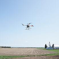
Drones can Lead to Better Worker Safety
Easily tackle projects in areas that are difficult, dirty or dangerous to access – such as challenging terrain, crumbling structures, high elevations, and areas impacted by natural disasters.
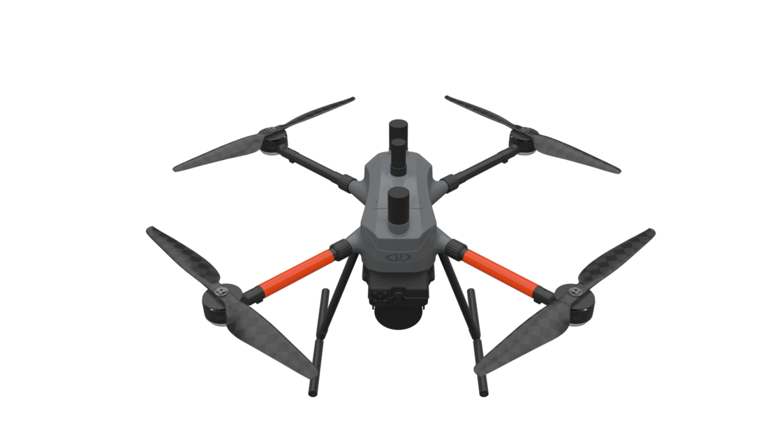
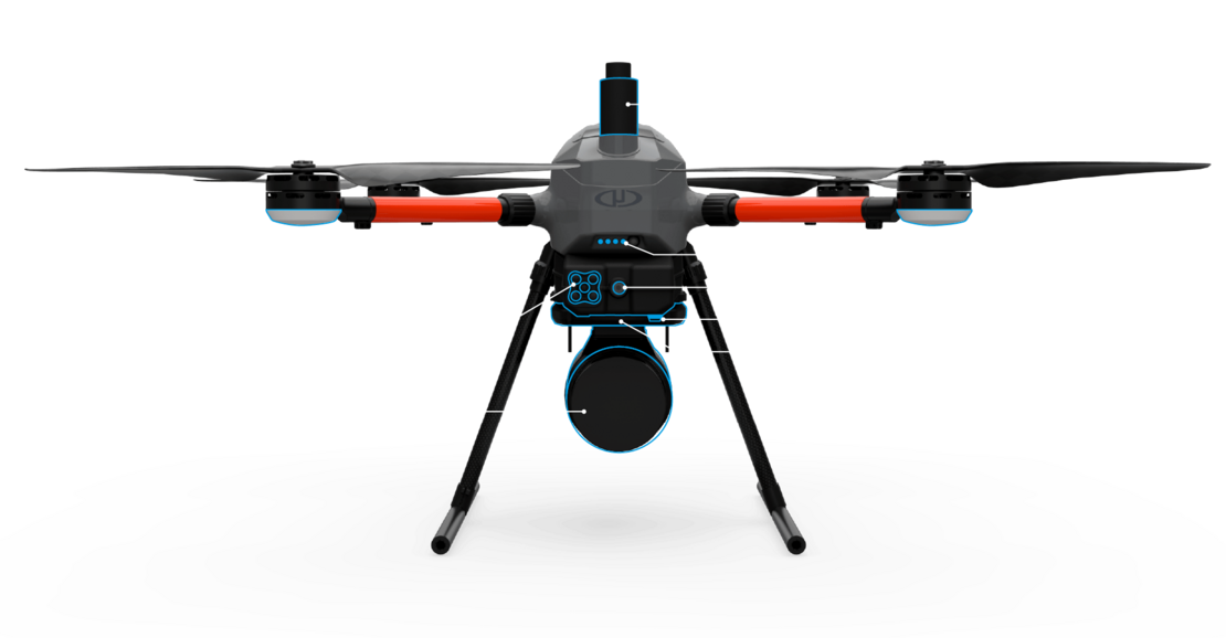
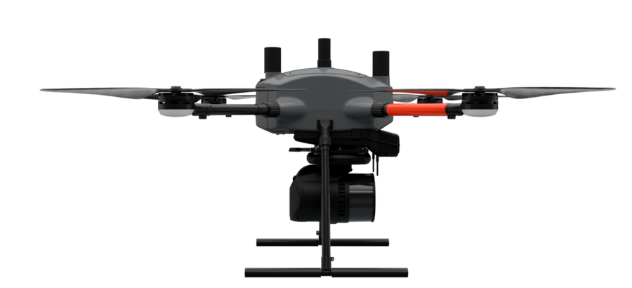
Built upon our 4th-gen drone technology, all EasyOne systems are more compact, more optimized, lighter, safer and more efficient. This system delivers integration unmatched in the drone surveying industry, making it easier than ever for you to plan, fly, collect, process and visualize your geospatial data projects.

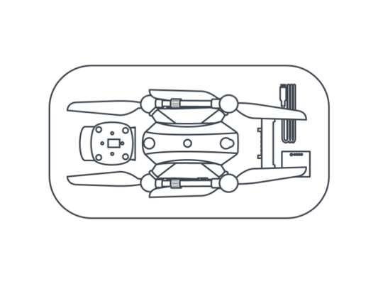
EasyOne features a significantly smaller operational form factor with the same payload capacity of the md4-1000 platform. In addition to a smaller operational form factor, the EasyOne packs down even smaller, fitting the drone, remote, charger, two batteries and the payload into a protective storage case that’s small and light enough to bring anywhere.
Pictured left: Gone are the days of needing a larger vehicle to transport your drone surveying equipment. The EasyOne drone packs down into a protective case that is 31.69” x 15.94” x 15.75” (805 mm x 405 mm x 400 mm)
The improved controller is completely integrated with mdCockpit. No more connecting a tablet to your remote!
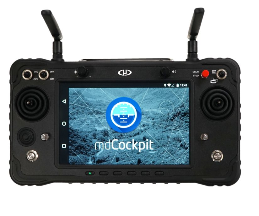
High level command of the drone without using the sticks on the remote
LESS IS MORE: The new EasyOne drone platform is smaller than competitive drones able to carry survey grade LiDAR equipment. It's easy to pack in a small vehicle, easy to carry in the field and easy to use on every project.

Frank DarmayanThis is a new beginning for the Microdrones aircraft platform. It fits in a case that’s less than a foot and a half wide. The mdCockpit mission planning screen is fully integrated into the RC. All sensitive onboard electronics are designed, manufactured and assembled in the USA and Germany. All this, yet it's just as powerful as our legacy drone platform.
CTO
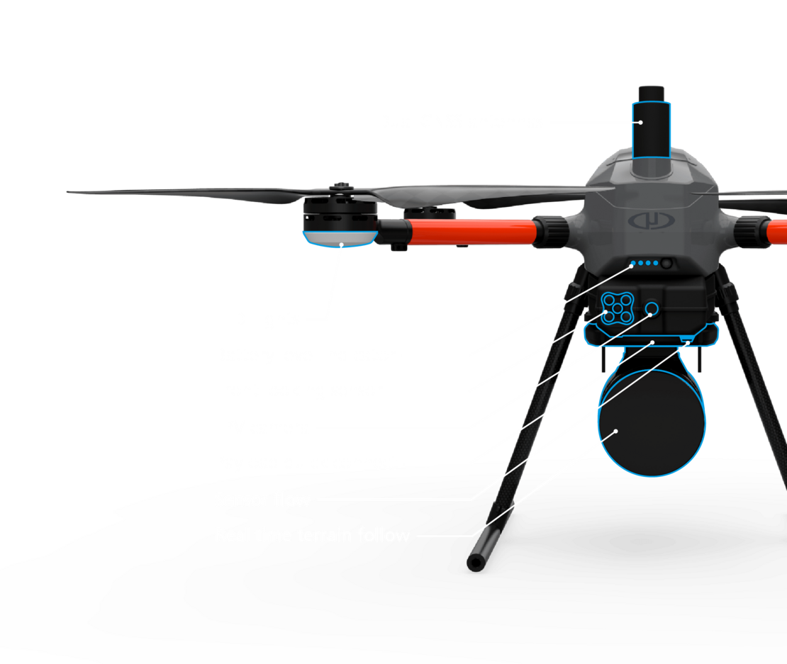
Real-time terrain follow uses the LiDAR payload to follow the terrain in real time.
During the flight, the LiDAR payload evaluates the terrain in real time below the UAV and reports the ground distance to the UAV.
The UAV uses that ground distance value to follow the desired height.
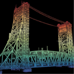
This allows the highest quality of data collection on the market, while adding a level of awareness and safety.
Watch a video about Real Time Terrain Follow here.
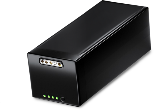
EasyOne includes a new Battery Management System that enables easy charging. Via a single connector, plug it in, and charging starts automatically if required.
Throughout battery maintenance and charging, the battery state is indicated via LEDs on the battery.

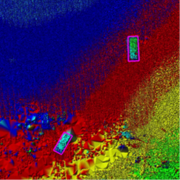
Brady ReischThe EasyOne checks all the boxes that our customers have asked for when it comes to a versatile and more compact drone surveying system. The LiDAR sensor provides very dense, point-rich data, with highly effective vegetation penetration. The set-up was straightforward, especially with the new payload quick-connect feature. Plus, the size alone makes it much more convenient for transport, especially when you’re working in isolated areas. It even fits under the tonneau cover in the back of my truck.
Virtual Design and Construction Reality
Capture Specialist, Kuker-Ranken
EasyOne is designed and assembled in the USA and Germany.
All onboard electronics except for motor controllers, motors and batteries are made in Germany.
Microdrones technology, firmware, software and workflow developed and refined since 2006 provides the brains of this powerful new system.
Our NDAA-compliant options take our smart sourcing to an even greater level with NDAA-compliant, sensor payload, RC, data link and software.
Accidents happen; it's a part of life and a part of work. No matter how careful you are, you should always expect the unexpected. This is why Microdrones offers a brand new Easy Replacement Program.
Microdrones technology, firmware, software and workflow developed and refined since 2006 is used with the new physical hardware to provide:


A FULLY INTEGRATED SOLUTION: EasyOne is an easy choice for serious geospatial pros. You get a drone, payload, RC, flight planning, post processing software, workflow, training and support all from one company. Our product and team becomes an extension of yours.

Vivien Heriard-DubreuilOur original UHR and UHR Lite LiDAR systems were a great success. We build on that today by integrating these powerful sensor packages with our newest airframe the EasyOne to bring you EasyOneLiDARUHR and UHR Lite.
CEO
EasyOneLiDARUHR+, UHR & UHR Lite are versatile packages that can be used for a wide range of applications.
PLATFORM
COMMUNICATIONS
PAYLOAD
SURVEY EQUIPMENT SOFTWARE
LP360 Drone is a powerful ecosystem that will enable you to quickly and efficiently process geospatial data. Your system will include LP360 Drone, as well as Strip Align and Desktop Photo Add-Ons.
Microdrones is committed to constant, customer focused improvement. As such we are developing cutting edge, integrated technology that evolves rapidly.
For those of you with an older system, we are always eager to help you upgrade your previous Microdrones system to the latest standards so you can take advantage of new features and functionality.
Simply click this button to schedule a meeting with a member of our sales team, and they will assist you in collecting your current system information so they can prepare a price estimate to upgrade.
Easily tackle projects in areas that are difficult, dirty or dangerous to access – such as challenging terrain, crumbling structures, high elevations, and areas impacted by natural disasters.
Collecting data previously required extensive groundwork or very expensive manned aircraft. Using a drone allows quick and affordable data collection; that’s one of the most important benefits for geospatial professionals.
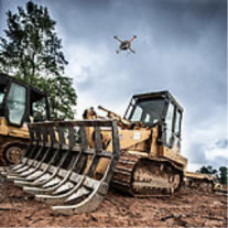
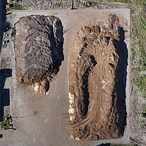
Survey live construction or mining sites without interrupting people, plans or machinery. You’ll no longer have to stop work and equipment to collect the data you need, making you more valuable to your customers.
Customers are curious about UAV surveying technology – so providing it demonstrates that a business is an industry leader at the helm. Faster, more efficient data collection differentiates you from competitors and positions you as a subject matter expert in an emerging technology.
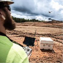
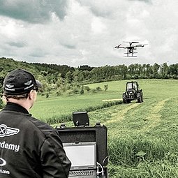
Our professional UAV pilots offer complete onsite Microdrones UAV training to both dealers and end-user customers to ensure they are fully capable of deploying their drone packages in the field, ready to achieve immediate results.


Size
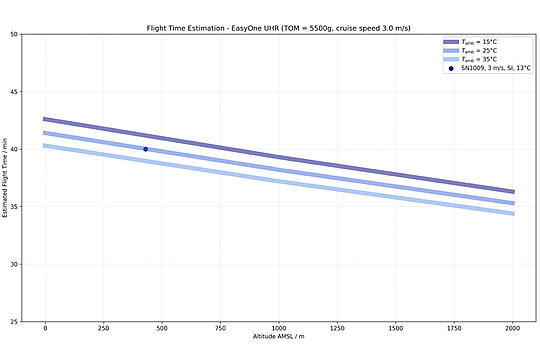
Flight time (estimated)
app. 40 min with UHR payload at our location (app. 300 m ASL)
Packaged weight
5500 g
Platform
2000 g
Battery
2100 g
Payload
1400 g
Max take off mass
5700 g
Drone, Sensor, batteries and remote all packs down to fit into one convenient carrying case.
Platform
EasyOne
Payload
Software
Takeoff Weight (TOW)
5.6 kg
System Operation Temperature
-10 °C to 40 °C
14 °F to 104 °F
Scanner Performance
GNSS/INS Performance
Survey System Performance
Photogrammetry
* 1 σ @ 50 m, nadir and with Strip Align
| Flight Altitude AGL (1,2) (m/ft) | 40/130 | 60/200 | 80/260 | 100/330 |
|---|---|---|---|---|
| Area Coverage at 20% Overlap (hectare/acres)(3) | 87/214 | 121/299 | 149/368 | 171/423 |
| Area Coverage at 35% Overlap (hectare/acres)(3) | 72/179 | 102/253 | 129/318 | 150/372 |
| Area Coverage at 50% Overlap (hectare/acres)(3) | 57/141 | 82/203 | 104/258 | 124/308 |
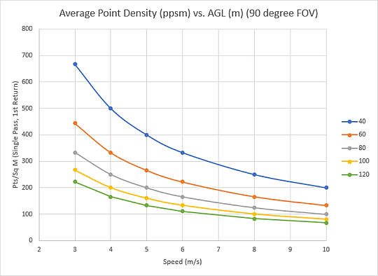
| Speed (m/s) | Average Point Density in pts/m2 (2,3) (Single Pass, 90 degree FOV, 1st Return Only) | |||
| 3 | 667 | 444 | 333 | 267 |
| 4 | 500 | 333 | 250 | 200 |
| 5 | 400 | 266 | 200 | 160 |
| 6 | 333 | 222 | 166 | 133 |
| 8 | 250 | 166 | 125 | 100 |
| 10 | 200 | 133 | 100 | 80 |
| Camera GSD (mm) | 9.4 | 14.1 | 18.8 | 23.5 |
| Swath width (m/ft) at 56° FOV | 42/138 | 63/207 | 85/279 | 106/348 |
| Swath width (m/ft) at 90° FOV | 80/262 | 120/394 | 160/525 | 200/656 |
| Swath width (m/ft) at 110° FOV | 114/374 | 171/561 | 228/751 | 285/935 |
| Number of Laser Returns | 2 | 2 | 2 | 2 |
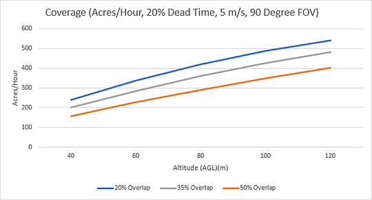
(1) Flight Altitude Above Ground Level (AGL)
(2)Coverage estimated for approximately 25 minutes of flight time.
(3) Point density calculated for Single Pass, 90 Degree FOV, 1st Return Only.
Platform
EasyOne
Payload
Software
Takeoff Weight (TOW)
5.6 kg
System Operation Temperature
-10 °C to 40 °C
14 °F to 104 °F
Scanner Performance
GNSS/INS Performance
System Performance
Photogrammetry
| Flight Altitude AGL (1,2) (m/ft) | 40/130 | 60/200 | 80/260 | 100/330 |
|---|---|---|---|---|
| Area Coverage at 20% Overlap (hectare/acres)(3) | 87/214 | 121/299 | 149/368 | 171/423 |
| Area Coverage at 35% Overlap (hectare/acres)(3) | 72/179 | 102/253 | 129/318 | 150/372 |
| Area Coverage at 50% Overlap (hectare/acres)(3) | 57/141 | 82/203 | 104/258 | 124/308 |
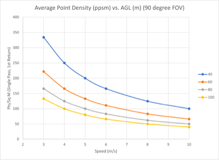
| Speed (m/s) | Average Point Density in pts/m2 (2,3) (Single Pass, 90 degree FOV, 1st Return Only) | |||
| 3 | 334 | 222 | 166 | 133 |
| 4 | 250 | 166 | 125 | 100 |
| 5 | 200 | 133 | 100 | 80 |
| 6 | 166 | 111 | 83 | 66 |
| 8 | 125 | 83 | 62 | 50 |
| 10 | 100 | 66 | 50 | 40 |
| Camera GSD (mm) | 9.4 | 14.1 | 18.8 | 23.5 |
| Swath width (m/ft) at 56° FOV | 42/138 | 63/207 | 85/279 | 106/348 |
| Swath width (m/ft) at 90° FOV | 80/262 | 120/394 | 160/525 | 200/656 |
| Swath width (m/ft) at 110° FOV | 114/374 | 171/561 | 229/751 | 285/935 |
| Number of Laser Returns | 2 | 2 | 2 | 2 |
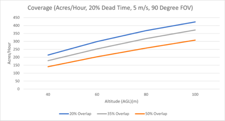
(1) Flight Altitude Above Ground Level (AGL)
(2)Coverage estimated for approximately 25 minutes of flight time.
(3) Point density calculated for Single Pass, 90 Degree FOV, 1st Return Only.